IMAGES TAKEN NEAR TO
PR7 1SR
Introduction
This page details the photographs taken nearby to PR7 1SR by members of the Geograph project.
The Geograph project started in 2005 with the aim of publishing, organising and preserving representative images for every square kilometre of Great Britain, Ireland and the Isle of Man.

There are currently over 7.5m images from over14,400 individuals and you can help contribute to the project by visiting https://www.geograph.org.uk
Image Map
Images are licensed for reuse under creativecommons.org/licenses/by-sa/2.0
Notes
- Clicking on the map will re-center to the selected point.
- The higher the marker number, the further away the image location is from the centre of the postcode.
Image Listing (9 Images Found)
Images are licensed for reuse under creativecommons.org/licenses/by-sa/2.0
Image
Details
Distance
5
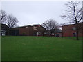
St Michael's C of E High School, Chorley
Off Astley Road.
Image: © JThomas
Taken: 22 Nov 2014
0.12 miles
6
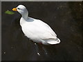
Gosling at Astley Hall
Awaiting bread from willing children.
Image: © Phil Platt
Taken: 22 Apr 2011
0.20 miles
7
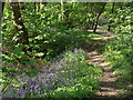
In a bluebell wood
In the grounds of Astley Hall. Is there anything more sure to stir the soul than an English wood adorned in spring with bluebells?
Image: © Phil Platt
Taken: 22 Apr 2011
0.21 miles
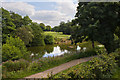
9
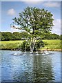
Fountain and Lake, Astley Park
The lake is situated below, and to the south-east of, Astley Hall.
Image: © David Dixon
Taken: 11 Jun 2014
0.25 miles