IMAGES TAKEN NEAR TO
Arley Street, CHORLEY, PR7 1SP
Introduction
This page details the photographs taken nearby to Arley Street, PR7 1SP by members of the Geograph project.
The Geograph project started in 2005 with the aim of publishing, organising and preserving representative images for every square kilometre of Great Britain, Ireland and the Isle of Man.

There are currently over 7.5m images from over14,400 individuals and you can help contribute to the project by visiting https://www.geograph.org.uk
Image Map
Images are licensed for reuse under creativecommons.org/licenses/by-sa/2.0
Notes
- Clicking on the map will re-center to the selected point.
- The higher the marker number, the further away the image location is from the centre of the postcode.
Image Listing (183 Images Found)
Images are licensed for reuse under creativecommons.org/licenses/by-sa/2.0
Image
Details
Distance
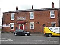
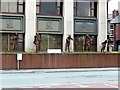
2
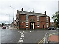
Traders Taphouse
A public house on Hollinshead Street at the junction with Clifford Street
Image: © Kevin Waterhouse
Taken: 22 Jul 2024
0.03 miles
3
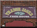
Trader Jacks, Chorley
http://www.geograph.org.uk/photo/4492431
Image: © Ian S
Taken: 25 May 2015
0.03 miles
4
Trader Jacks, Chorley
http://www.geograph.org.uk/photo/4492439
Image: © Ian S
Taken: 25 May 2015
0.04 miles
5
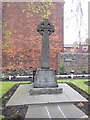
WWI War Memorial
At Hollinshead Street Independent Chapel, Chorley
Image: © Ian S
Taken: 25 May 2015
0.04 miles
6
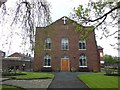
Hollinshead Street Independent Chapel, Chorley
Image: © Ian S
Taken: 25 May 2015
0.05 miles
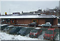
9
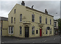
The Imperial
On the corner of Union Street and Fellery Street close to the town centre.
Image: © michael ely
Taken: 8 May 2009
0.09 miles