IMAGES TAKEN NEAR TO
Chatsworth Close, CHORLEY, PR7 1LZ
Introduction
This page details the photographs taken nearby to Chatsworth Close, PR7 1LZ by members of the Geograph project.
The Geograph project started in 2005 with the aim of publishing, organising and preserving representative images for every square kilometre of Great Britain, Ireland and the Isle of Man.

There are currently over 7.5m images from over14,400 individuals and you can help contribute to the project by visiting https://www.geograph.org.uk
Image Map
Images are licensed for reuse under creativecommons.org/licenses/by-sa/2.0
Notes
- Clicking on the map will re-center to the selected point.
- The higher the marker number, the further away the image location is from the centre of the postcode.
Image Listing (18 Images Found)
Images are licensed for reuse under creativecommons.org/licenses/by-sa/2.0
Image
Details
Distance
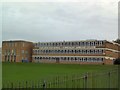
3
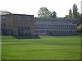
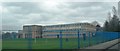
High School in Lancashire
From the playing fields.
Image: © Phil Platt
Taken: 22 Apr 2011
0.14 miles
4
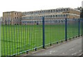
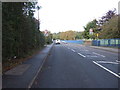
Parklands High School
This view is taken from the A581, Southport Road.
Image: © Ann Cook
Taken: 11 Aug 2010
0.16 miles
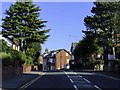
5
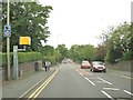
Southport Road, Chorley
The road on the left is Balmoral Road.
Image: © Ann Cook
Taken: 11 Aug 2010
0.18 miles
8
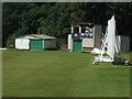
Chorley Cricket Club - Scoreboard
The scoreboard at Chorley CC's Windsor Park ground.
Image: © BatAndBall
Taken: 9 Jun 2011
0.20 miles
10
Parklands High School
A centre of excellence for language learning, on the A581 just west of Chorley town centre.
Image: © Roger May
Taken: 26 Oct 2005
0.21 miles