IMAGES TAKEN NEAR TO
Hollinshead Street, CHORLEY, PR7 1EP
Introduction
This page details the photographs taken nearby to Hollinshead Street, PR7 1EP by members of the Geograph project.
The Geograph project started in 2005 with the aim of publishing, organising and preserving representative images for every square kilometre of Great Britain, Ireland and the Isle of Man.

There are currently over 7.5m images from over14,400 individuals and you can help contribute to the project by visiting https://www.geograph.org.uk
Image Map
Images are licensed for reuse under creativecommons.org/licenses/by-sa/2.0
Notes
- Clicking on the map will re-center to the selected point.
- The higher the marker number, the further away the image location is from the centre of the postcode.
Image Listing (227 Images Found)
Images are licensed for reuse under creativecommons.org/licenses/by-sa/2.0
Image
Details
Distance
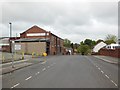
2
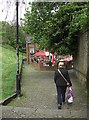
Church Brow, Chorley
Descending the cobbled steps that lead to the Swan with Two Necks pub and the Water Street car park.
Image: © michael ely
Taken: 8 May 2009
0.04 miles
3
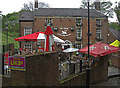
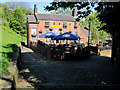
Swan with Two Necks, Chorley
At the bottom of Church Brow. The pub was plastered with UKIP posters when I passed by.
Image: © michael ely
Taken: 8 May 2009
0.04 miles
4
St. Laurence, Chorley
Church of England parish church seen from the bottom of Church Brow.
Image: © philandju
Taken: 10 Dec 2013
0.05 miles
5
The Swan With Two Necks
'The Swan With Two Necks' is at the end of Hollinshead Street below Church Brow. It is Grade II listed.
Image: © John S Turner
Taken: 28 Apr 2011
0.05 miles
6
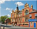
Chorley: The Education Support Centre
Image: © Mr Eugene Birchall
Taken: 18 May 2010
0.05 miles
7
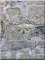
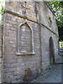
Early bench mark in Hollinshead Street, Chorley
This bench mark, at the end of Hollinshead Street, was recorded on the 1848 Town Plan levelled at 250.8 feet. The top edge of the stone seems to have been used as the datum line. The stone structure that the mark is on is the former north west entrance to St Laurence' church yard - See Image and Image
Image: © John S Turner
Taken: 28 Apr 2011
0.05 miles
8
Old graffiti in Hollinshead Street, Chorley
The former entrance to St Laurence' church yard not only has a bench mark cut into it Image, but also these old initials - FP.
Image: © John S Turner
Taken: 28 Apr 2011
0.05 miles
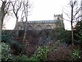
9
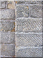
Former entrance to St Laurence' churchyard
This stylish gateway is hidden away at the bottom of Church Brow where it meets Hollinshead Street. This side of the gateway has an early bench mark Image and some old carved initials Image
Image: © John S Turner
Taken: 28 Apr 2011
0.05 miles
10
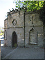
Former entrance to St Laurence' churchyard #2
An impressive stone gateway at the bottom of Church Brow where it meets Hollinshead Street. See also Image
Image: © John S Turner
Taken: 28 Apr 2011
0.05 miles