IMAGES TAKEN NEAR TO
Maytree Court, CHORLEY, PR6 9SL
Introduction
This page details the photographs taken nearby to Maytree Court, PR6 9SL by members of the Geograph project.
The Geograph project started in 2005 with the aim of publishing, organising and preserving representative images for every square kilometre of Great Britain, Ireland and the Isle of Man.

There are currently over 7.5m images from over14,400 individuals and you can help contribute to the project by visiting https://www.geograph.org.uk
Image Map
Images are licensed for reuse under creativecommons.org/licenses/by-sa/2.0
Notes
- Clicking on the map will re-center to the selected point.
- The higher the marker number, the further away the image location is from the centre of the postcode.
Image Listing (12 Images Found)
Images are licensed for reuse under creativecommons.org/licenses/by-sa/2.0
Image
Details
Distance
1
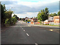
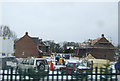
Westhoughton Road (A6)
A short dual carriageway section of the A6 between Adlington and Heath Charnock.
Image: © David Dixon
Taken: 29 Aug 2010
0.12 miles

3
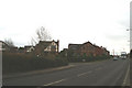
Old and new
New housing beside the old road to Scotland through Manchester, the A6.
Image: © David Long
Taken: 7 Feb 2006
0.15 miles
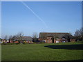
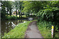
8

Secluded corner
Boats moored within yards of the busy A6.
Image: © David Long
Taken: 7 Feb 2006
0.21 miles
9
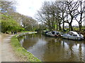
A tight turn on the Leeds Liverpool Canal
Image: © Raymond Knapman
Taken: 14 Apr 2014
0.24 miles
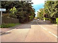
10
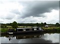
Canal and cloud
Foreboding cloud over the Leeds and Liverpool Canal near Adlington.
Image: © philandju
Taken: 24 Aug 2017
0.25 miles