IMAGES TAKEN NEAR TO
Thirlmere Close, CHORLEY, PR6 9QD
Introduction
This page details the photographs taken nearby to Thirlmere Close, PR6 9QD by members of the Geograph project.
The Geograph project started in 2005 with the aim of publishing, organising and preserving representative images for every square kilometre of Great Britain, Ireland and the Isle of Man.

There are currently over 7.5m images from over14,400 individuals and you can help contribute to the project by visiting https://www.geograph.org.uk
Image Map
Images are licensed for reuse under creativecommons.org/licenses/by-sa/2.0
Notes
- Clicking on the map will re-center to the selected point.
- The higher the marker number, the further away the image location is from the centre of the postcode.
Image Listing (3 Images Found)
Images are licensed for reuse under creativecommons.org/licenses/by-sa/2.0
Image
Details
Distance
2
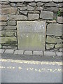
Old Boundary Marker by Babylon Lane, Anderton
Parish Boundary Marker by the UC road, in parish of Anderton (Chorley District), Babylon Lane, Anderton, set in wall, opposite No 124.
Inscription reads:-
BOUNDARY
Surveyed
Milestone Society National ID: LA_HCHAND02pb
Image: © Milestone Society
Taken: Unknown
0.08 miles