IMAGES TAKEN NEAR TO
Dill Hall Brow, CHORLEY, PR6 9HD
Introduction
This page details the photographs taken nearby to Dill Hall Brow, PR6 9HD by members of the Geograph project.
The Geograph project started in 2005 with the aim of publishing, organising and preserving representative images for every square kilometre of Great Britain, Ireland and the Isle of Man.

There are currently over 7.5m images from over14,400 individuals and you can help contribute to the project by visiting https://www.geograph.org.uk
Image Map
Images are licensed for reuse under creativecommons.org/licenses/by-sa/2.0
Notes
- Clicking on the map will re-center to the selected point.
- The higher the marker number, the further away the image location is from the centre of the postcode.
Image Listing (51 Images Found)
Images are licensed for reuse under creativecommons.org/licenses/by-sa/2.0
Image
Details
Distance
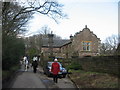
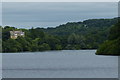
2
Houses by Upper Rivington Reservoir
On a private road, but public footpath.
Image: © philandju
Taken: 3 Apr 2013
0.02 miles
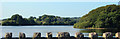
3
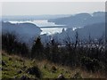
Upper and Lower Rivington Reservoirs
From a view point above Anglezarke Reservoir, on a hazy afternoon. The southern end of Anglezarke Reservoir can be seen behind the trees in the foreground.
Image: © philandju
Taken: 17 Mar 2016
0.07 miles
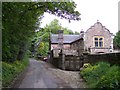
4
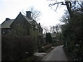
Riders and The Coach House on "The Street"
Riders and The Coach House on "The Street", Lane Ends.
Image: © Sue Adair
Taken: 25 Mar 2007
0.07 miles
5
The Street, Lane Ends
The Street, Lane Ends, a dark, damp lane which leads along the western edge of the Upper Rivington Reservoir.
Image: © Sue Adair
Taken: 25 Mar 2007
0.07 miles
6
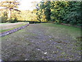
Dried up Spillway from Anglezarke Reservoir
Image: © Peter Bond
Taken: 23 Jun 2011
0.08 miles
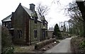
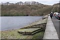
7
"The Street" across Upper Rivington Reservoir
"The Street" is the name of the large listed building which is on the bridleway of the same name. This is the view from the embankment at the southern end of the Upper Rivington Reservoir.
Image: © PopUpPirate
Taken: 17 Aug 2006
0.10 miles
9
House overlooking Upper Rivington Reservoir
The house is called The Street, surrounded by Street Wood.
Image: © Mat Fascione
Taken: 16 Jul 2016
0.11 miles
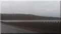
10
South side of Anglezarke Reservoir
A view from the W end of the dam separating Anglezarke and Upper Rivington Reservoirs.
Image: © Jim Barton
Taken: 26 Dec 2011
0.12 miles