IMAGES TAKEN NEAR TO
Hut Lane, CHORLEY, PR6 9FP
Introduction
This page details the photographs taken nearby to Hut Lane, PR6 9FP by members of the Geograph project.
The Geograph project started in 2005 with the aim of publishing, organising and preserving representative images for every square kilometre of Great Britain, Ireland and the Isle of Man.

There are currently over 7.5m images from over14,400 individuals and you can help contribute to the project by visiting https://www.geograph.org.uk
Image Map
Images are licensed for reuse under creativecommons.org/licenses/by-sa/2.0
Notes
- Clicking on the map will re-center to the selected point.
- The higher the marker number, the further away the image location is from the centre of the postcode.
Image Listing (9 Images Found)
Images are licensed for reuse under creativecommons.org/licenses/by-sa/2.0
Image
Details
Distance
2
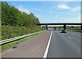
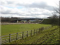
Southbound M61, Hut Lane Overbridge
The bridge taking Hut Lane, from Long Lane to Hallsworth Fold Farm, over the M61 motorway.
Image: © David Dixon
Taken: 20 Apr 2012
0.03 miles
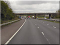
3
Bridge over the M61 at Hallsworth Fold Farm
Image: © Anthony Parkes
Taken: 14 Jan 2012
0.04 miles
4
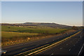
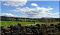
A view of the M61 from Hut Lane bridge with Winter Hill and Rivington Pike beyond
Image: © Ian Greig
Taken: 14 Jan 2012
0.07 miles
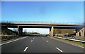
5
Hut Lane crossing
Bridge over M61 motorway where Hut Lane crosses to Hailsworth Fold Farm, Heath Charnock.
Image: © Margaret Clough
Taken: 16 Feb 2006
0.08 miles
7
Abyssinia, River Yarrow
The River Yarrow, Limbrick, Chorley, in an area previously known as Abyssinia.
Image: © PopUpPirate
Taken: 1 Jul 2006
0.19 miles
8
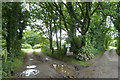
Footpaths off Long Lane, Heath Charnock
The path on the left leads across Chorley Golf Club to Hall o' th' Hill Farm. The path on the right leads to Holland Fold.
Image: © Gary Rogers
Taken: 16 Aug 2015
0.21 miles
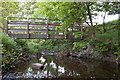
9
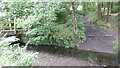
Footbridge and fording point over the River Yarrow
On a path known as Water Street between Back Lane and Hallsworth Fold Farm
Image: © Gary Rogers
Taken: 16 Aug 2015
0.21 miles