IMAGES TAKEN NEAR TO
Long Lane, CHORLEY, PR6 9EN
Introduction
This page details the photographs taken nearby to Long Lane, PR6 9EN by members of the Geograph project.
The Geograph project started in 2005 with the aim of publishing, organising and preserving representative images for every square kilometre of Great Britain, Ireland and the Isle of Man.

There are currently over 7.5m images from over14,400 individuals and you can help contribute to the project by visiting https://www.geograph.org.uk
Image Map
Images are licensed for reuse under creativecommons.org/licenses/by-sa/2.0
Notes
- Clicking on the map will re-center to the selected point.
- The higher the marker number, the further away the image location is from the centre of the postcode.
Image Listing (18 Images Found)
Images are licensed for reuse under creativecommons.org/licenses/by-sa/2.0
Image
Details
Distance
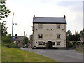
2
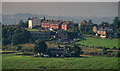
Blindhurst
Blindhurst seen from Moor Lane.
Image: © Peter McDermott
Taken: 28 Sep 2013
0.03 miles
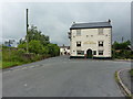

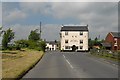
9
Heath Charnock: The Bay Horse Inn
Image: © Mr Eugene Birchall
Taken: 18 Feb 2005
0.07 miles
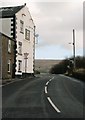
10
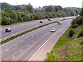
M61
Looking north from the bridge at New Road
Image: © David Dixon
Taken: 4 Jun 2010
0.09 miles