IMAGES TAKEN NEAR TO
Osprey Close, CHORLEY, PR6 9BN
Introduction
This page details the photographs taken nearby to Osprey Close, PR6 9BN by members of the Geograph project.
The Geograph project started in 2005 with the aim of publishing, organising and preserving representative images for every square kilometre of Great Britain, Ireland and the Isle of Man.

There are currently over 7.5m images from over14,400 individuals and you can help contribute to the project by visiting https://www.geograph.org.uk
Image Map
Images are licensed for reuse under creativecommons.org/licenses/by-sa/2.0
Notes
- Clicking on the map will re-center to the selected point.
- The higher the marker number, the further away the image location is from the centre of the postcode.
Image Listing (13 Images Found)
Images are licensed for reuse under creativecommons.org/licenses/by-sa/2.0
Image
Details
Distance
1
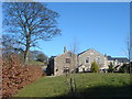
Heapey House
This substantial stone building bears the date 1723.
Image: © Margaret Clough
Taken: 2 Mar 2006
0.15 miles
2
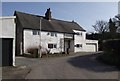
Moody House Farm
Sparkling white in the afternoon sun.
Image: © philandju
Taken: 18 Feb 2013
0.16 miles
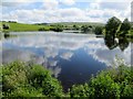
4
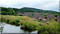
Gone fishin'
Putting the Knowley Reservoir to good use.
An incongruous housing estate beyond apparently in the middle of nowhere?
Image: © Jonathan Billinger
Taken: 14 Aug 2013
0.18 miles
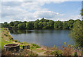
5
Heapey Reservoir No. 2
Near White Coppice.
Image: © philandju
Taken: 21 May 2014
0.18 miles
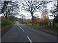
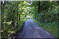
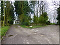
8
Tithe Barn Lane
The junction of Tithe Barn Lane, Higher House Lane and Heapey Road
Image: © David Dixon
Taken: 26 Feb 2019
0.19 miles
9
Public Footpath sign at Higher Healey
Image: © Raymond Knapman
Taken: 13 Apr 2015
0.20 miles
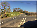
10
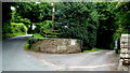
Private drive - public footpath
Heapey Road to the left.
Image: © Jonathan Billinger
Taken: 14 Aug 2013
0.21 miles