IMAGES TAKEN NEAR TO
Dorking Road, CHORLEY, PR6 8TR
Introduction
This page details the photographs taken nearby to Dorking Road, PR6 8TR by members of the Geograph project.
The Geograph project started in 2005 with the aim of publishing, organising and preserving representative images for every square kilometre of Great Britain, Ireland and the Isle of Man.

There are currently over 7.5m images from over14,400 individuals and you can help contribute to the project by visiting https://www.geograph.org.uk
Image Map
Images are licensed for reuse under creativecommons.org/licenses/by-sa/2.0
Notes
- Clicking on the map will re-center to the selected point.
- The higher the marker number, the further away the image location is from the centre of the postcode.
Image Listing (5 Images Found)
Images are licensed for reuse under creativecommons.org/licenses/by-sa/2.0
Image
Details
Distance
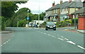
1
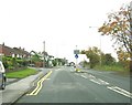
Blackburn Road at the junction with Guildford Avenue
Image: © Ann Cook
Taken: 31 Oct 2010
0.13 miles
2
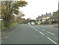
Blackburn Road at the junction with Guildford Avenue
Image: © Ann Cook
Taken: 31 Oct 2010
0.14 miles
4
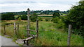
Stile by Blackburn Road
The path meanders across fields and is prevented from entering Chorley by the M61 in the way.
Image: © Jonathan Billinger
Taken: 14 Aug 2013
0.17 miles
![Blackburn Road [B6228]](https://s1.geograph.org.uk/geophotos/02/29/46/2294601_77726e4a_120x120.jpg)