IMAGES TAKEN NEAR TO
Higher Bank Street, CHORLEY, PR6 8SF
Introduction
This page details the photographs taken nearby to Higher Bank Street, PR6 8SF by members of the Geograph project.
The Geograph project started in 2005 with the aim of publishing, organising and preserving representative images for every square kilometre of Great Britain, Ireland and the Isle of Man.

There are currently over 7.5m images from over14,400 individuals and you can help contribute to the project by visiting https://www.geograph.org.uk
Image Map
Images are licensed for reuse under creativecommons.org/licenses/by-sa/2.0
Notes
- Clicking on the map will re-center to the selected point.
- The higher the marker number, the further away the image location is from the centre of the postcode.
Image Listing (36 Images Found)
Images are licensed for reuse under creativecommons.org/licenses/by-sa/2.0
Image
Details
Distance
1
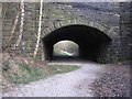
Railway Bridge, Brinscall
Old railway bridge now a walkway.
Image: © James K Muldoon
Taken: 7 Apr 2007
0.04 miles
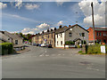
2

Course of Disused Railway, Withnell
The footpath along the dismantled railway, viewed from Bury Lane at Withnell.
Image: © David Dixon
Taken: 7 Jul 2012
0.05 miles
3
Sign for Withnel Nature Trail
This occupies land where the Chorley to Cherry Tree railway once ran
Image: © Raymond Knapman
Taken: 23 May 2011
0.10 miles
4
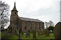
St Joseph Catholic Church, Withnell
Image: © Alexander P Kapp
Taken: 25 Jul 2007
0.11 miles
5
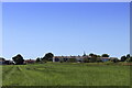
Looking towards the Village of Withnell
As seen from the footpath to Abbey Village
Image: © Chris Heaton
Taken: 17 Jul 2021
0.12 miles
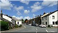
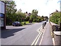
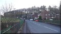
7
Withnell
The junction of Bury Lane and Railway Road in the village of Withnell.
Image: © David Dixon
Taken: 7 Jul 2012
0.13 miles
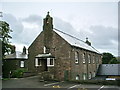
8
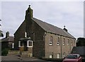
St Joseph Roman Catholic Church Withnell
Founded before 1892 the building was still in use when this image was taken.
Image: © Steve Houldsworth
Taken: Unknown
0.13 miles
9
Norcross Brow, Withnell
Crossing the cutting which once carried The Goit, which fed the canal network from reservoirs to the east.
Image: © Richard Webb
Taken: 26 Dec 2016
0.16 miles