IMAGES TAKEN NEAR TO
The Beeches, CHORLEY, PR6 8RA
Introduction
This page details the photographs taken nearby to The Beeches, PR6 8RA by members of the Geograph project.
The Geograph project started in 2005 with the aim of publishing, organising and preserving representative images for every square kilometre of Great Britain, Ireland and the Isle of Man.

There are currently over 7.5m images from over14,400 individuals and you can help contribute to the project by visiting https://www.geograph.org.uk
Image Map
Images are licensed for reuse under creativecommons.org/licenses/by-sa/2.0
Notes
- Clicking on the map will re-center to the selected point.
- The higher the marker number, the further away the image location is from the centre of the postcode.
Image Listing (48 Images Found)
Images are licensed for reuse under creativecommons.org/licenses/by-sa/2.0
Image
Details
Distance
1
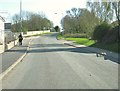
Sandy Lane at the junction with Near Meadow
Near Meadow is on the right. There is a new road, on the left, leading into a new housing development.
Image: © Ann Cook
Taken: 9 Apr 2011
0.04 miles
2
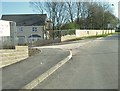
A new road off Sandy Lane
This road leads into a new housing development.
Image: © Ann Cook
Taken: 9 Apr 2011
0.04 miles
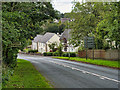
5
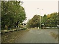
Turn left for Whittle-le-Woods
Sandy Lane is the road to the left. This was the original road leading to the A6. Now Westwood Road [to the right] takes the traffic to the A6.
Image: © Ann Cook
Taken: 31 Oct 2010
0.06 miles
6
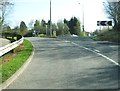
Sandy Lane approaching a roundabout
The roundabout is on the B5256.
Image: © Ann Cook
Taken: 9 Apr 2011
0.08 miles

8
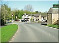
Lord Nelson public house
This is at the junction of Chorley Old road and Sandy Lane.
Image: © Ann Cook
Taken: 9 Apr 2011
0.08 miles
9
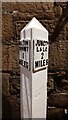
Canal Milestone, Lord Nelson Pub, Clayton-le-Woods
Originally located on the Lancaster Canal (South End) probably about 320m to the East of the pub at what was then Radburn Bridge. Now between Westwood Road and the M61.
Inscription: Walton / Summit / 1 / Miles // Junctᴺ / L & L C / 2 / Miles
Milestone National ID: LAN-00
Image: © Cherry Chapman
Taken: 9 Dec 2022
0.08 miles
10
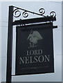
Sign for the Lord Nelson, Clayton-le-Woods
Image: © JThomas
Taken: 25 Oct 2018
0.08 miles