IMAGES TAKEN NEAR TO
Canterbury Close, CHORLEY, PR6 8PZ
Introduction
This page details the photographs taken nearby to Canterbury Close, PR6 8PZ by members of the Geograph project.
The Geograph project started in 2005 with the aim of publishing, organising and preserving representative images for every square kilometre of Great Britain, Ireland and the Isle of Man.

There are currently over 7.5m images from over14,400 individuals and you can help contribute to the project by visiting https://www.geograph.org.uk
Image Map
Images are licensed for reuse under creativecommons.org/licenses/by-sa/2.0
Notes
- Clicking on the map will re-center to the selected point.
- The higher the marker number, the further away the image location is from the centre of the postcode.
Image Listing (20 Images Found)
Images are licensed for reuse under creativecommons.org/licenses/by-sa/2.0
Image
Details
Distance
1

Brinscall Cricket Club
Brinscall CC play in Division 1 of the Ribblesdale League.
The picture shows the changing rooms.
Image: © BatAndBall
Taken: 23 Jun 2011
0.06 miles
2

Brinscall and Withnell Athletic and Recreation Ground
Image: © David Dixon
Taken: 7 Jul 2012
0.08 miles
3
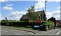
Hillside Methodist Church
At the junction of Parke Road and School Lane in Brinscall.
Image: © philandju
Taken: 10 Jun 2022
0.09 miles
4

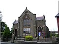
Hillside Methodist Church
The Methodist church on School Lane, at Brinscall.
Image: © David Dixon
Taken: 7 Jul 2012
0.10 miles
5
Hillside Methodist Brinscall
The building was still in use when this image was taken.
Image: © Steve Houldsworth
Taken: Unknown
0.10 miles
6

Brinscall Cricket Club - Ground
The picture shows the entrance to Brinscall CC's ground. It was taken from in front of the clubhouse. The scorebox and a sightscreen can also be seen.
Image: © BatAndBall
Taken: 23 Jun 2011
0.11 miles
7
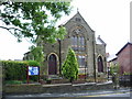
Hillside Methodist Church, Brinscall
Image: © Alexander P Kapp
Taken: 25 Jul 2007
0.11 miles
9
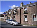
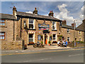
"The Oak Tree" (Pub) 58 School Lane, Brinscall, Chorley, Lancashire
Image: © Robert Wade
Taken: 25 Sep 2010
0.16 miles
10

Originally a Church Building
The building in the picture at the junction of Dick Lane and School Lane Brinscall was originally a church, situated by the Bus stop and with a war memorial in the grounds, it had been closed as a church long before the image was taken.
Image: © Steve Houldsworth
Taken: Unknown
0.17 miles