IMAGES TAKEN NEAR TO
Top O'The Lane, CHORLEY, PR6 8PA
Introduction
This page details the photographs taken nearby to Top O'The Lane, PR6 8PA by members of the Geograph project.
The Geograph project started in 2005 with the aim of publishing, organising and preserving representative images for every square kilometre of Great Britain, Ireland and the Isle of Man.

There are currently over 7.5m images from over14,400 individuals and you can help contribute to the project by visiting https://www.geograph.org.uk
Image Map
Images are licensed for reuse under creativecommons.org/licenses/by-sa/2.0
Notes
- Clicking on the map will re-center to the selected point.
- The higher the marker number, the further away the image location is from the centre of the postcode.
Image Listing (16 Images Found)
Images are licensed for reuse under creativecommons.org/licenses/by-sa/2.0
Image
Details
Distance
1

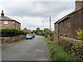
Cottages at Top o' th' Lane
The hamlet is little more than this row of cottages.
Image: © philandju
Taken: 9 Jul 2012
0.01 miles
2
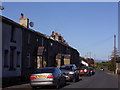
Weavers' Cottages on Denham Lane
The hamlet of Top o' th' Lane is basically a string of former weavers' cottages along Denham Lane.
Image: © David Dixon
Taken: 9 Sep 2020
0.04 miles
3
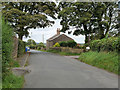
Top o' th' lane
Top o' th' lane is a small row of cottages standing on their own about one mile from the village of Brindle.
Image: © Ann Cook
Taken: 2 Nov 2006
0.04 miles
4

Renovation incomplete
It looks like the renovation of this cottage in Top o' th' Lane started, but has not been finished.
Image: © philandju
Taken: 9 Jul 2012
0.08 miles
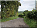
5
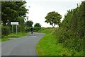
Approaching Top o'th' Lane
A small hamlet near Brindle in Lancashire.
Image: © philandju
Taken: 21 Aug 2023
0.09 miles
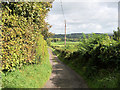
9
Track off Denham Lane
Also a public footpath leading to Breworth Fold Farm and beyond.
Image: © philandju
Taken: 21 Aug 2023
0.14 miles
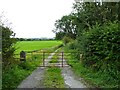
10

Footpath through the fields
Connecting Denham Lane and Holt Lane.
Image: © philandju
Taken: 9 Jul 2012
0.17 miles