IMAGES TAKEN NEAR TO
Sandy Lane, CHORLEY, PR6 8NQ
Introduction
This page details the photographs taken nearby to Sandy Lane, PR6 8NQ by members of the Geograph project.
The Geograph project started in 2005 with the aim of publishing, organising and preserving representative images for every square kilometre of Great Britain, Ireland and the Isle of Man.

There are currently over 7.5m images from over14,400 individuals and you can help contribute to the project by visiting https://www.geograph.org.uk
Image Map
Images are licensed for reuse under creativecommons.org/licenses/by-sa/2.0
Notes
- Clicking on the map will re-center to the selected point.
- The higher the marker number, the further away the image location is from the centre of the postcode.
Image Listing (10 Images Found)
Images are licensed for reuse under creativecommons.org/licenses/by-sa/2.0
Image
Details
Distance
1
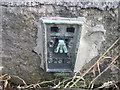
Ordnance Survey Flush Bracket G2512
This can be found on the roadside wall of a building at Tullis Farm in Sandy Lane.
For more detail see : http://www.bench-marks.org.uk/bm11329
Image: © Peter Wood
Taken: 21 Jun 2014
0.06 miles
![A sharp bend on Sandy Lane [B5256]](https://s2.geograph.org.uk/geophotos/02/02/44/2024446_8d721e38_120x120.jpg)
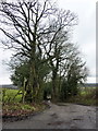
3
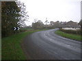
Sharp bend in Sandy Lane (B5256)
Towards Leyland.
Image: © JThomas
Taken: 25 Oct 2018
0.07 miles
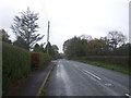
4
![Sandy Lane [B5256] and the junction with Pippin Street](https://s1.geograph.org.uk/geophotos/02/02/43/2024333_9f0bd117_120x120.jpg)
Sandy Lane [B5256] and the junction with Pippin Street
Image: © Ann Cook
Taken: 21 Aug 2010
0.08 miles
5
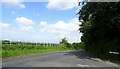
Pippin Street
At its junction with Sandy Lane near Thorpe Green.
Image: © philandju
Taken: 10 Jun 2022
0.08 miles
6
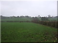
Grazing and hedgerow, Thorpe Green
Off Sandy Lane (B5256).
Image: © JThomas
Taken: 25 Oct 2018
0.10 miles
9
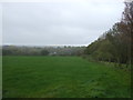
Grassland beside woodland
Off Sandy Lane (B5256).
Image: © JThomas
Taken: 25 Oct 2018
0.22 miles
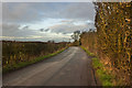
10
Sandy Lane (B5256) towards Leyland
Looking south west.
Image: © JThomas
Taken: 25 Oct 2018
0.23 miles