IMAGES TAKEN NEAR TO
Copthurst Lane, CHORLEY, PR6 8LR
Introduction
This page details the photographs taken nearby to Copthurst Lane, PR6 8LR by members of the Geograph project.
The Geograph project started in 2005 with the aim of publishing, organising and preserving representative images for every square kilometre of Great Britain, Ireland and the Isle of Man.

There are currently over 7.5m images from over14,400 individuals and you can help contribute to the project by visiting https://www.geograph.org.uk
Image Map
Images are licensed for reuse under creativecommons.org/licenses/by-sa/2.0
Notes
- Clicking on the map will re-center to the selected point.
- The higher the marker number, the further away the image location is from the centre of the postcode.
Image Listing (79 Images Found)
Images are licensed for reuse under creativecommons.org/licenses/by-sa/2.0
Image
Details
Distance
3
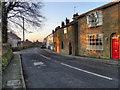
Johnson's Hillock
Houses on Town Lane at Johnson's Hillock.
Image: © David Dixon
Taken: 30 Jan 2012
0.13 miles
4
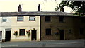
Terraced cottages
Facing Dark Lane, Johnson's Hillock.
Image: © Jonathan Billinger
Taken: 14 Aug 2013
0.13 miles
5
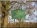
St Chad's RC Church, Town Lane signboard
To the right of the church (east)
Image: © W J Taylor
Taken: 29 Dec 2008
0.13 miles
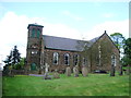
6
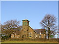
St Chad's RC Church, Town Lane
From the Red Cat pub car park.
Image: © W J Taylor
Taken: 29 Dec 2008
0.13 miles
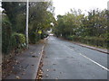
7

Town Lane, Johnson's Hillock
Viewed from the Dark Lane junction.
Image: © Jonathan Billinger
Taken: 14 Aug 2013
0.13 miles
10
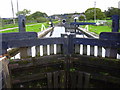
Leeds-Liverpool Canal, Wheelton, Lancashire
Image: © Robert Wade
Taken: 25 Sep 2010
0.14 miles