IMAGES TAKEN NEAR TO
Bolton Road, CHORLEY, PR6 8BY
Introduction
This page details the photographs taken nearby to Bolton Road, PR6 8BY by members of the Geograph project.
The Geograph project started in 2005 with the aim of publishing, organising and preserving representative images for every square kilometre of Great Britain, Ireland and the Isle of Man.

There are currently over 7.5m images from over14,400 individuals and you can help contribute to the project by visiting https://www.geograph.org.uk
Image Map
Images are licensed for reuse under creativecommons.org/licenses/by-sa/2.0
Notes
- Clicking on the map will re-center to the selected point.
- The higher the marker number, the further away the image location is from the centre of the postcode.
Image Listing (21 Images Found)
Images are licensed for reuse under creativecommons.org/licenses/by-sa/2.0
Image
Details
Distance
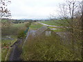
2
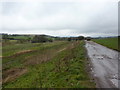
Originally the Cherry Tree & Chorley Line now dismantled
Image: © Alexander P Kapp
Taken: 17 Mar 2011
0.07 miles
3
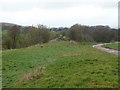
Originally the Cherry Tree & Chorley Line now dismantled
Image: © Alexander P Kapp
Taken: 17 Mar 2011
0.09 miles

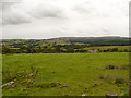
6
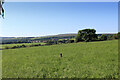
Looking South over Countryside from near Edge End Farm
Looking towards Abbey Village.
Image: © Chris Heaton
Taken: 17 Jul 2021
0.14 miles
7
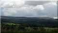
Farmland and woods
Off the A675 near Abbey Village.
Image: © philandju
Taken: 16 Aug 2022
0.14 miles
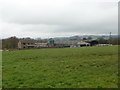
8
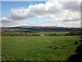
Pasture land near Abbey Village
Darwen Moor Tower on the left.
Image: © Karl and Ali
Taken: 7 Apr 2011
0.15 miles
10
Originally the Cherry Tree & Chorley Line now dismantled
Image: © Alexander P Kapp
Taken: 17 Mar 2011
0.17 miles