IMAGES TAKEN NEAR TO
Spring Crescent, CHORLEY, PR6 8AD
Introduction
This page details the photographs taken nearby to Spring Crescent, PR6 8AD by members of the Geograph project.
The Geograph project started in 2005 with the aim of publishing, organising and preserving representative images for every square kilometre of Great Britain, Ireland and the Isle of Man.

There are currently over 7.5m images from over14,400 individuals and you can help contribute to the project by visiting https://www.geograph.org.uk
Image Map
Images are licensed for reuse under creativecommons.org/licenses/by-sa/2.0
Notes
- Clicking on the map will re-center to the selected point.
- The higher the marker number, the further away the image location is from the centre of the postcode.
Image Listing (59 Images Found)
Images are licensed for reuse under creativecommons.org/licenses/by-sa/2.0
Image
Details
Distance
2
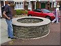
Whittle Springs, the well
Last remains of former popular spa
Image: © W J Taylor
Taken: 17 Jul 2005
0.06 miles
8
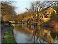
Whittle Springs
The Leeds and Liverpool Canal at Whittle Springs.
Image: © David Dixon
Taken: 30 Jan 2012
0.09 miles
9
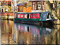
Scallywag
Narrowboat moored on the Leeds and Liverpool Canal at Whittle Springs.
Image: © David Dixon
Taken: 30 Jan 2012
0.10 miles
10
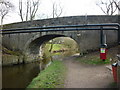
Leeds and Liverpool Canal Bridge #80
Moss Lane.
Image: © Ian S
Taken: 19 Mar 2011
0.10 miles