IMAGES TAKEN NEAR TO
Lucas Way, PR6 7YQ
Introduction
This page details the photographs taken nearby to Lucas Way, PR6 7YQ by members of the Geograph project.
The Geograph project started in 2005 with the aim of publishing, organising and preserving representative images for every square kilometre of Great Britain, Ireland and the Isle of Man.

There are currently over 7.5m images from over14,400 individuals and you can help contribute to the project by visiting https://www.geograph.org.uk
Image Map
Images are licensed for reuse under creativecommons.org/licenses/by-sa/2.0
Notes
- Clicking on the map will re-center to the selected point.
- The higher the marker number, the further away the image location is from the centre of the postcode.
Image Listing (7 Images Found)
Images are licensed for reuse under creativecommons.org/licenses/by-sa/2.0
Image
Details
Distance
3
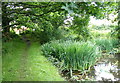
End of the Walton Summit Branch of the Leeds and Liverpool Canal
This branch canal is the original route of Lancaster Canal.
Image: © Mat Fascione
Taken: 16 Jul 2016
0.23 miles
4
Spur off the Leeds-Liverpool Canal, Wheelton, Lancashire
Image: © Robert Wade
Taken: 25 Sep 2010
0.24 miles
6
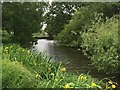
Lancaster Canal
The end of the (very) short southern section near Whittle-le-Woods.
Image: © John H Darch
Taken: 21 Jun 2015
0.24 miles
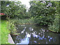
7
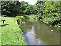
No boats, please; ducks only on this canal
Today the South End of the Lancaster Canal comes to a dead end only about 350 yards from the junction with the Leeds & Liverpool Canal at Johnson's Hillock, near Whittle-le-Woods. A "No Entry" sign at the junction forbids boats to disturb the local wildlife, though pedestrians may sit and cast bread upon the waters to watch the ducks scrambling for a slice of the action.
Image: © A-M-Jervis
Taken: 15 Aug 2007
0.24 miles