IMAGES TAKEN NEAR TO
Chorley Old Road, CHORLEY, PR6 7QZ
Introduction
This page details the photographs taken nearby to Chorley Old Road, PR6 7QZ by members of the Geograph project.
The Geograph project started in 2005 with the aim of publishing, organising and preserving representative images for every square kilometre of Great Britain, Ireland and the Isle of Man.

There are currently over 7.5m images from over14,400 individuals and you can help contribute to the project by visiting https://www.geograph.org.uk
Image Map
Images are licensed for reuse under creativecommons.org/licenses/by-sa/2.0
Notes
- Clicking on the map will re-center to the selected point.
- The higher the marker number, the further away the image location is from the centre of the postcode.
Image Listing (35 Images Found)
Images are licensed for reuse under creativecommons.org/licenses/by-sa/2.0
Image
Details
Distance
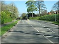
1
Chorley Old Road at the junction with Fern Meadow
Image: © Ann Cook
Taken: 9 Apr 2011
0.04 miles
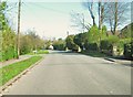
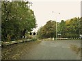
2
Chorley Old Road at the junction with Osborne Drive
Image: © Ann Cook
Taken: 9 Apr 2011
0.04 miles
3
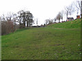
Lancaster Canal, Whittle-le-Woods
Looking north along the route of the Lancaster Canal.
The recent small housing estate on the right has not yet appeared on the 1:50000 map.
Image: © Ian Taylor
Taken: 25 Mar 2009
0.15 miles
4
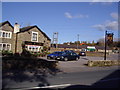
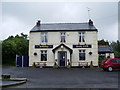
Public house
This is the Lord Nelson public house. Sadly, for them, the road changes in recent years means that this pub is now tucked away in a back-water. Worth finding.
Image: © Ann Cook
Taken: 2 Nov 2006
0.16 miles
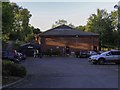
5
Dog Inn, Chorley Old Road, Whittle-le-Woods
Image: © Alexander P Kapp
Taken: 26 Jun 2008
0.17 miles
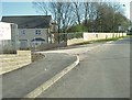
7
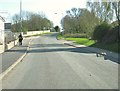
Sandy Lane at the junction with Near Meadow
Near Meadow is on the right. There is a new road, on the left, leading into a new housing development.
Image: © Ann Cook
Taken: 9 Apr 2011
0.18 miles
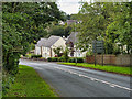
9
Turn left for Whittle-le-Woods
Sandy Lane is the road to the left. This was the original road leading to the A6. Now Westwood Road [to the right] takes the traffic to the A6.
Image: © Ann Cook
Taken: 31 Oct 2010
0.18 miles
10
A new road off Sandy Lane
This road leads into a new housing development.
Image: © Ann Cook
Taken: 9 Apr 2011
0.19 miles