IMAGES TAKEN NEAR TO
Hill Top Lane, CHORLEY, PR6 7QS
Introduction
This page details the photographs taken nearby to Hill Top Lane, PR6 7QS by members of the Geograph project.
The Geograph project started in 2005 with the aim of publishing, organising and preserving representative images for every square kilometre of Great Britain, Ireland and the Isle of Man.

There are currently over 7.5m images from over14,400 individuals and you can help contribute to the project by visiting https://www.geograph.org.uk
Image Map
Images are licensed for reuse under creativecommons.org/licenses/by-sa/2.0
Notes
- Clicking on the map will re-center to the selected point.
- The higher the marker number, the further away the image location is from the centre of the postcode.
Image Listing (6 Images Found)
Images are licensed for reuse under creativecommons.org/licenses/by-sa/2.0
Image
Details
Distance
1
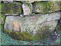
Stone commemorating rebuilding of wall by volunteers
On the 'Carradise'; the Bell because it was organised by Councillor James Eric Bell, and the date of the rebuilding. Stone cut by a local mason.
Image: © W J Taylor
Taken: 11 Apr 2006
0.12 miles
2
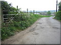
Entrance To North Bank Farm
Tom Dixon and later his son John Dixon supplied many customers with milk from the dairy herd at North Bank Farm. In the 1950's and early 60's I would occasionally ride with Tom in his van delivering milk in Whittle-le-Woods and Chorley.
Image: © John Tustin
Taken: 24 Apr 2009
0.14 miles
3
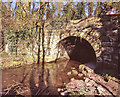
Tunnel under Lancaster Canal
This tunnel was built for the River Lostock to pass under the embankment for the southern section of the Lancaster Canal. It even has a "towpath".
The canal was finally abandoned when the M61 motorway was built - it cut across the canal about 100m from here.
The river also passes through a culvert in the M61 embankment (immediately upstream of this tunnel).
Image: © Ian Taylor
Taken: 6 Mar 2009
0.17 miles
5
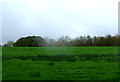
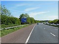
Grazing off Birchin Lane
The M61 Motorway runs behind the trees.
Image: © JThomas
Taken: 25 Oct 2018
0.23 miles
6
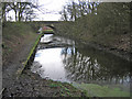
Lancaster Canal, Whittle-le-Woods
I believe this 50m length is the only remaining section of the Lancaster Canal between Johnson's Hillock [SD5820] and Walton Summit [SD5824], that still resembles a canal.
This southern section of the canal was never linked to the northern section, except by a tramway, due to the expense of crossing the River Ribble.
It was finally abandoned when the M61 motorway was built.
Image: © Ian Taylor
Taken: 25 Mar 2009
0.24 miles