IMAGES TAKEN NEAR TO
Ash Field, CHORLEY, PR6 7QP
Introduction
This page details the photographs taken nearby to Ash Field, PR6 7QP by members of the Geograph project.
The Geograph project started in 2005 with the aim of publishing, organising and preserving representative images for every square kilometre of Great Britain, Ireland and the Isle of Man.

There are currently over 7.5m images from over14,400 individuals and you can help contribute to the project by visiting https://www.geograph.org.uk
Image Map
Images are licensed for reuse under creativecommons.org/licenses/by-sa/2.0
Notes
- Clicking on the map will re-center to the selected point.
- The higher the marker number, the further away the image location is from the centre of the postcode.
Image Listing (45 Images Found)
Images are licensed for reuse under creativecommons.org/licenses/by-sa/2.0
Image
Details
Distance
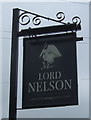
2
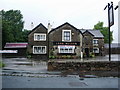
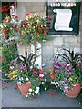
Lord Nelson public house
This is at the junction of Chorley Old road and Sandy Lane.
Image: © Ann Cook
Taken: 9 Apr 2011
0.05 miles
3
The Lord Nelson, Clayton-le-Woods
On Sandy Lane.
Image: © JThomas
Taken: 25 Oct 2018
0.05 miles
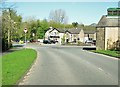
4
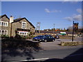
Radburn Brow, looking towards the A6
This view is taken from the end of Chorley Old Road. The car park of the Lord Nelson is on the right.
Image: © Ann Cook
Taken: 9 Apr 2011
0.05 miles
5
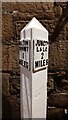
Canal Milestone, Lord Nelson Pub, Clayton-le-Woods
Originally located on the Lancaster Canal (South End) probably about 320m to the East of the pub at what was then Radburn Bridge. Now between Westwood Road and the M61.
Inscription: Walton / Summit / 1 / Miles // Junctᴺ / L & L C / 2 / Miles
Milestone National ID: LAN-00
Image: © Cherry Chapman
Taken: 9 Dec 2022
0.05 miles
7
Canal Milepost
This mile post appears to have been moved about 50yds from the previous course of the Walton Summit Branch of the Leeds Liverpool Canal, which is now buried under the M61.
It has been re-erected at the corner of a pub which may well have been a canal serving pub, even if not directly alongside the canal. It is certainly old enough and does appear to be on the old map that comes up when checking the location.
Image: © John Lomas
Taken: 12 Aug 2005
0.06 miles
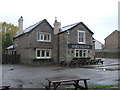
8
Public house
This is the Lord Nelson public house. Sadly, for them, the road changes in recent years means that this pub is now tucked away in a back-water. Worth finding.
Image: © Ann Cook
Taken: 2 Nov 2006
0.07 miles
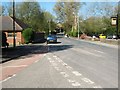
10
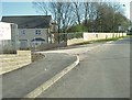
A new road off Sandy Lane
This road leads into a new housing development.
Image: © Ann Cook
Taken: 9 Apr 2011
0.10 miles