IMAGES TAKEN NEAR TO
Shaw Brow, CHORLEY, PR6 7LE
Introduction
This page details the photographs taken nearby to Shaw Brow, PR6 7LE by members of the Geograph project.
The Geograph project started in 2005 with the aim of publishing, organising and preserving representative images for every square kilometre of Great Britain, Ireland and the Isle of Man.

There are currently over 7.5m images from over14,400 individuals and you can help contribute to the project by visiting https://www.geograph.org.uk
Image Map
Images are licensed for reuse under creativecommons.org/licenses/by-sa/2.0
Notes
- Clicking on the map will re-center to the selected point.
- The higher the marker number, the further away the image location is from the centre of the postcode.
Image Listing (44 Images Found)
Images are licensed for reuse under creativecommons.org/licenses/by-sa/2.0
Image
Details
Distance
1
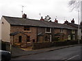
Whittle le Woods: cottages on Town Lane
Image: © Margaret Clough
Taken: 10 Mar 2006
0.03 miles
2
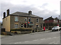
Whittle-le-Woods Post Office
The post office on Shaw Brow
Image: © David Dixon
Taken: 25 Feb 2012
0.04 miles
3
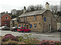
The Roebuck
A public house on Shaw Brow, at Whittle-le-Woods.
Image: © David Dixon
Taken: 25 Feb 2012
0.06 miles
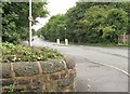
5
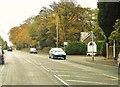
Passing the entrance to Shaw Hill Golf and Country Club
Image: © Ann Cook
Taken: 31 Oct 2010
0.07 miles
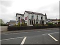
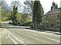
6
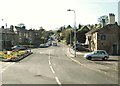
School Brow meets Shaw Brow
The Roebuck public house is on the right.
Image: © Ann Cook
Taken: 9 Apr 2011
0.07 miles
7
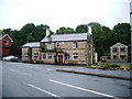
The Roebuck Waterhouse Green, Whittle-le-Woods
Image: © Alexander P Kapp
Taken: 26 Jun 2008
0.07 miles
8
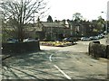
Bridge over the River Lostock
This is on School Brow.
Image: © Ann Cook
Taken: 9 Apr 2011
0.08 miles
9
Looking north along the A6 from the junction with Dawson Lane
Image: © Ann Cook
Taken: 4 Aug 2010
0.09 miles
10
Chorley Old Road at the junction with Town Lane
This view is from the end of School Brow.
Image: © Ann Cook
Taken: 9 Apr 2011
0.09 miles