IMAGES TAKEN NEAR TO
Smithills Close, CHORLEY, PR6 0EG
Introduction
This page details the photographs taken nearby to Smithills Close, PR6 0EG by members of the Geograph project.
The Geograph project started in 2005 with the aim of publishing, organising and preserving representative images for every square kilometre of Great Britain, Ireland and the Isle of Man.

There are currently over 7.5m images from over14,400 individuals and you can help contribute to the project by visiting https://www.geograph.org.uk
Image Map
Images are licensed for reuse under creativecommons.org/licenses/by-sa/2.0
Notes
- Clicking on the map will re-center to the selected point.
- The higher the marker number, the further away the image location is from the centre of the postcode.
Image Listing (36 Images Found)
Images are licensed for reuse under creativecommons.org/licenses/by-sa/2.0
Image
Details
Distance
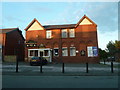
2
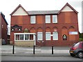
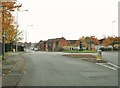
St Peter's Parish Club on Eaves Lane, Chorley
Image: © Ian S
Taken: 25 May 2015
0.07 miles
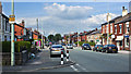
3
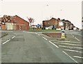
Roundabout at the end of Eaves Lane
Harper's Lane is to the left and Botany Brow to the right.
Image: © Ann Cook
Taken: 31 Oct 2010
0.08 miles
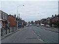
5
Roundabout at the junction of Botany Brow, Harper's Lane and Eaves Lane
Image: © Ann Cook
Taken: 31 Oct 2010
0.11 miles
7
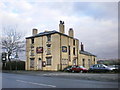
The Talbot
What remains after the fire.
Image: © Alexander P Kapp
Taken: 2 Jan 2009
0.11 miles
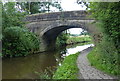
8
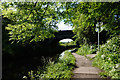
Leeds & Liverpool Canal
Bridge 78, Bagganley Bridge.
Image: © Ian S
Taken: 10 Jun 2019
0.11 miles
9
Bagganley Bridge No 78
Crossing the Leeds and Liverpool Canal on the edge of Chorley.
Image: © Mat Fascione
Taken: 16 Jul 2016
0.11 miles
10
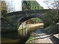
Leeds and Liverpool Canal Bridge #78
Bagganley Lane
Image: © Ian S
Taken: 19 Mar 2011
0.12 miles