IMAGES TAKEN NEAR TO
Whimberry Close, CHORLEY, PR6 0BZ
Introduction
This page details the photographs taken nearby to Whimberry Close, PR6 0BZ by members of the Geograph project.
The Geograph project started in 2005 with the aim of publishing, organising and preserving representative images for every square kilometre of Great Britain, Ireland and the Isle of Man.

There are currently over 7.5m images from over14,400 individuals and you can help contribute to the project by visiting https://www.geograph.org.uk
Image Map
Images are licensed for reuse under creativecommons.org/licenses/by-sa/2.0
Notes
- Clicking on the map will re-center to the selected point.
- The higher the marker number, the further away the image location is from the centre of the postcode.
Image Listing (39 Images Found)
Images are licensed for reuse under creativecommons.org/licenses/by-sa/2.0
Image
Details
Distance
1
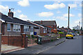
Montcliffe Road, Chorley
Montcliffe Road has a mixture of houses and semi-detached bungalows. It runs parallel to the Leeds & Liverpool Canal although that is not obvious from here.
Image: © Stephen McKay
Taken: 25 Apr 2023
0.03 miles
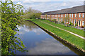
2
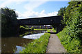
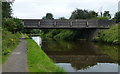
Leeds & Liverpool Canal
Bridge 77A Froom Street Bridge.
Image: © Ian S
Taken: 10 Jun 2019
0.08 miles
3
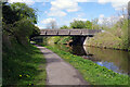
Froom Street Bridge, Leeds & Liverpool Canal
Many bridges on the canal network are very attractive but not so this utilitarian concrete affair in the Chorley suburbs. Froom Street at this point is more like a country lane.
Image: © Stephen McKay
Taken: 25 Apr 2023
0.08 miles
4
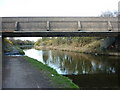
Leeds and Liverpool Canal Bridge #77A
Froom Street.
Image: © Ian S
Taken: 19 Mar 2011
0.08 miles
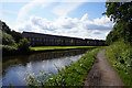
7
Leeds & Liverpool Canal, Chorley
The canal skirts the eastern edge of Chorley and here it is overlooked by houses on Mariner's Walk.
Image: © Stephen McKay
Taken: 25 Apr 2023
0.13 miles
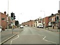
9
Eaves Lane and the junction with Aniline Street
Aniline Street is on the left and Froom Street is on the right.
Image: © Ann Cook
Taken: 31 Oct 2010
0.14 miles
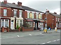
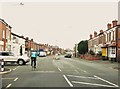
10
Pedestrian crossing on Eaves Lane
Pennine Road is on the left and Stump Lane is immediately before the Derby Arms.
Image: © Ann Cook
Taken: 31 Oct 2010
0.14 miles