IMAGES TAKEN NEAR TO
Daisy Meadow, PRESTON, PR5 8DL
Introduction
This page details the photographs taken nearby to Daisy Meadow, PR5 8DL by members of the Geograph project.
The Geograph project started in 2005 with the aim of publishing, organising and preserving representative images for every square kilometre of Great Britain, Ireland and the Isle of Man.

There are currently over 7.5m images from over14,400 individuals and you can help contribute to the project by visiting https://www.geograph.org.uk
Image Map (Loading...)


Getting Data...Please wait
Leaflet Map data © OpenStreetMap
Images are licensed for reuse under creativecommons.org/licenses/by-sa/2.0
Notes
- Clicking on the map will re-center to the selected point.
- The higher the marker number, the further away the image location is from the centre of the postcode.
Image Listing (14 Images Found)
Images are licensed for reuse under creativecommons.org/licenses/by-sa/2.0
Image
Details
Distance
1
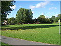
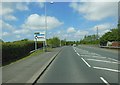
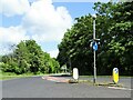
Clayton Brook village green
Looking North from SD5798324288
Image: © Paul Glenville
Taken: 24 Aug 2006
0.04 miles
3
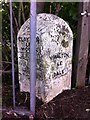
Old Boundary Marker by the A6, Preston Road, Clayton Brook
Parish Boundary Marker by the A6, in parish of Clayton-le-Woods (Chorley District), Preston Road, opposite Greenways Rest Home, behind railings, West side of road.
Inscription reads:-
: CLAYTON / LE / WOODS : : WALTON / LE / DALE :
Carved bench mark on top.
Surveyed
Milestone Society National ID: LA_CYPS04pb
Image: © Milestone Society
Taken: Unknown
0.08 miles
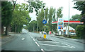
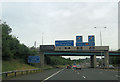
10
Clayton Brook Road
At its junction with Preston Road (A6).
Image: © philandju
Taken: 10 Jun 2022
0.23 miles