IMAGES TAKEN NEAR TO
Carr Field, PRESTON, PR5 8BT
Introduction
This page details the photographs taken nearby to Carr Field, PR5 8BT by members of the Geograph project.
The Geograph project started in 2005 with the aim of publishing, organising and preserving representative images for every square kilometre of Great Britain, Ireland and the Isle of Man.

There are currently over 7.5m images from over14,400 individuals and you can help contribute to the project by visiting https://www.geograph.org.uk
Image Map
Images are licensed for reuse under creativecommons.org/licenses/by-sa/2.0
Notes
- Clicking on the map will re-center to the selected point.
- The higher the marker number, the further away the image location is from the centre of the postcode.
Image Listing (30 Images Found)
Images are licensed for reuse under creativecommons.org/licenses/by-sa/2.0
Image
Details
Distance
1
![Westwood Road [B5256] approaching the junction with Clayton Brook Road](https://s3.geograph.org.uk/geophotos/02/02/61/2026135_b06e201d_120x120.jpg)
Westwood Road [B5256] approaching the junction with Clayton Brook Road
Image: © Ann Cook
Taken: 21 Aug 2010
0.08 miles
2
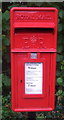
Close up, Elizabeth II postbox on Clayton Brook Road
Postbox No. PR5 220.
See Image] for wider view.
Image: © JThomas
Taken: 25 Oct 2018
0.09 miles
3
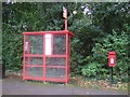
Elizabeth II postbox and bus shelter on Clayton Brook Road
Postbox No. PR5 220.
See Image] for close up.
Image: © JThomas
Taken: 25 Oct 2018
0.09 miles
4
![Westwood Road [B5256] and the junction with Clayton Brook Road](https://s0.geograph.org.uk/geophotos/02/02/43/2024320_7fe24ffc_120x120.jpg)
Westwood Road [B5256] and the junction with Clayton Brook Road
Image: © Ann Cook
Taken: 21 Aug 2010
0.10 miles
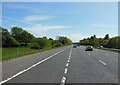
6
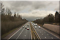
Motorway
This is the M61 taken from a bridge over the motorway. The bridge is on the B5256 between Leyland and Brindle.
Image: © Ann Cook
Taken: 2 Nov 2006
0.13 miles
8
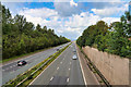
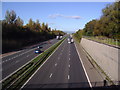
M61 near Clayton Brook
Looking north along the M61 from the bridge at Sandy Lane.
Image: © David Dixon
Taken: 9 Sep 2020
0.16 miles
9
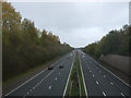
M61 northbound
View from the bridge on Sandy Lane (B5256).
Image: © JThomas
Taken: 25 Oct 2018
0.16 miles
