IMAGES TAKEN NEAR TO
Poplar Close, PRESTON, PR5 6RS
Introduction
This page details the photographs taken nearby to Poplar Close, PR5 6RS by members of the Geograph project.
The Geograph project started in 2005 with the aim of publishing, organising and preserving representative images for every square kilometre of Great Britain, Ireland and the Isle of Man.

There are currently over 7.5m images from over14,400 individuals and you can help contribute to the project by visiting https://www.geograph.org.uk
Image Map (Loading...)


Getting Data...Please wait
Leaflet Map data © OpenStreetMap
Images are licensed for reuse under creativecommons.org/licenses/by-sa/2.0
Notes
- Clicking on the map will re-center to the selected point.
- The higher the marker number, the further away the image location is from the centre of the postcode.
Image Listing (9 Images Found)
Images are licensed for reuse under creativecommons.org/licenses/by-sa/2.0
Image
Details
Distance
2
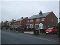
Semi detached houses on Collins Road, Bamber Bridge
Image: © JThomas
Taken: 25 Oct 2018
0.14 miles
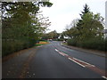
3

Collins Road, Bamber Bridge
Looking south west at the junction with Poplar Avenue.
Image: © JThomas
Taken: 25 Oct 2018
0.14 miles
4
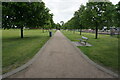
Turf zone WithyAvenue
Avenue of trees in Withy Grove Park, Bamber Bridge.
Image: © Ian S
Taken: 28 May 2023
0.18 miles
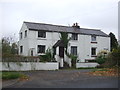
5
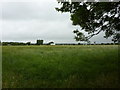
Pasture to the south of Woodlands Avenue, Bamber Bridge
Image: © Alexander P Kapp
Taken: 28 Jul 2010
0.20 miles
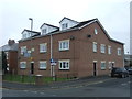
8
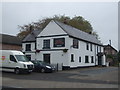
Ye Olde Original Withy Trees public house, Bamber Bridge
On Station Road.
Image: © JThomas
Taken: 25 Oct 2018
0.25 miles
9
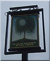
Sign for Ye Olde Original Withy Trees public house, Bamber Bridge
Image: © JThomas
Taken: 25 Oct 2018
0.25 miles