IMAGES TAKEN NEAR TO
Brindle Road, PRESTON, PR5 6RP
Introduction
This page details the photographs taken nearby to Brindle Road, PR5 6RP by members of the Geograph project.
The Geograph project started in 2005 with the aim of publishing, organising and preserving representative images for every square kilometre of Great Britain, Ireland and the Isle of Man.

There are currently over 7.5m images from over14,400 individuals and you can help contribute to the project by visiting https://www.geograph.org.uk
Image Map
Images are licensed for reuse under creativecommons.org/licenses/by-sa/2.0
Notes
- Clicking on the map will re-center to the selected point.
- The higher the marker number, the further away the image location is from the centre of the postcode.
Image Listing (13 Images Found)
Images are licensed for reuse under creativecommons.org/licenses/by-sa/2.0
Image
Details
Distance
1
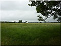
Pasture to the south of Woodlands Avenue, Bamber Bridge
Image: © Alexander P Kapp
Taken: 28 Jul 2010
0.14 miles
2
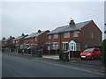
Semi detached houses on Collins Road, Bamber Bridge
Image: © JThomas
Taken: 25 Oct 2018
0.14 miles
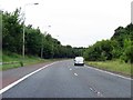
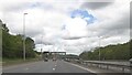
5
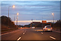
South Ribble : The M6 Motorway
Heading north through Lancashire on the M6 Motorway.
Image: © Lewis Clarke
Taken: 21 Apr 2016
0.22 miles
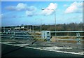
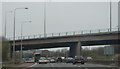
6
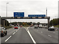
Southbound M6, Junction 30
To the left, the start of the southbound M61 whilst the southbound M6 continues in the three right hand lanes.
Image: © David Dixon
Taken: 27 Oct 2011
0.24 miles
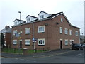
8

Collins Road, Bamber Bridge
Looking south west at the junction with Poplar Avenue.
Image: © JThomas
Taken: 25 Oct 2018
0.24 miles