IMAGES TAKEN NEAR TO
Brindle Road, PRESTON, PR5 6AP
Introduction
This page details the photographs taken nearby to Brindle Road, PR5 6AP by members of the Geograph project.
The Geograph project started in 2005 with the aim of publishing, organising and preserving representative images for every square kilometre of Great Britain, Ireland and the Isle of Man.

There are currently over 7.5m images from over14,400 individuals and you can help contribute to the project by visiting https://www.geograph.org.uk
Image Map (Loading...)


Getting Data...Please wait
Leaflet Map data © OpenStreetMap
Images are licensed for reuse under creativecommons.org/licenses/by-sa/2.0
Notes
- Clicking on the map will re-center to the selected point.
- The higher the marker number, the further away the image location is from the centre of the postcode.
Image Listing (23 Images Found)
Images are licensed for reuse under creativecommons.org/licenses/by-sa/2.0
Image
Details
Distance
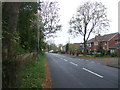
1
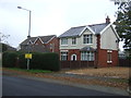
Houses on Brindle Road, Walton Summit Centre
Image: © JThomas
Taken: 25 Oct 2018
0.01 miles
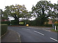
2
Brindle Road, Walton Summit Centre
Looking north west, junction with Craigflower Court.
Image: © JThomas
Taken: 25 Oct 2018
0.03 miles
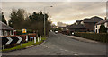
3
Sharp bend in Kellet Lane
Junction with Brindle Road, Walton Summit Centre.
Looking north east.
Image: © JThomas
Taken: 25 Oct 2018
0.07 miles
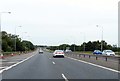
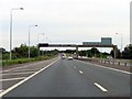
5
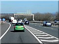
Northbound M61
Joining the northbound M61 via the sliproad from the M65.
Image: © David Dixon
Taken: 24 Mar 2014
0.13 miles
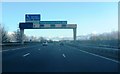
7
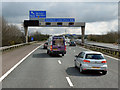
Southbound M61, Approaching Junction 9
The overhead gantry gives notice of Junction 9, for the M65, ahead.
Image: © David Dixon
Taken: 20 Apr 2012
0.15 miles