IMAGES TAKEN NEAR TO
St. Saviours Close, PRESTON, PR5 6AH
Introduction
This page details the photographs taken nearby to St. Saviours Close, PR5 6AH by members of the Geograph project.
The Geograph project started in 2005 with the aim of publishing, organising and preserving representative images for every square kilometre of Great Britain, Ireland and the Isle of Man.

There are currently over 7.5m images from over14,400 individuals and you can help contribute to the project by visiting https://www.geograph.org.uk
Image Map (Loading...)


Getting Data...Please wait
Leaflet Map data © OpenStreetMap
Images are licensed for reuse under creativecommons.org/licenses/by-sa/2.0
Notes
- Clicking on the map will re-center to the selected point.
- The higher the marker number, the further away the image location is from the centre of the postcode.
Image Listing (26 Images Found)
Images are licensed for reuse under creativecommons.org/licenses/by-sa/2.0
Image
Details
Distance
1
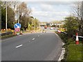
Sliproad onto the M6 at Junction 29 (Walton Summit)
Image: © David Dixon
Taken: 11 Apr 2014
0.09 miles
2
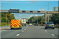
Bamber Bridge : M6 Motorway
The M6 Motorway between Junction 29 and Junction 30 (Blacow Bridge).
Image: © Lewis Clarke
Taken: 23 Sep 2019
0.10 miles
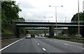
4
Slip road to M6 at Junction 29
Northbound slip road from A6 at Junction 29
Image: © John Firth
Taken: 9 May 2011
0.11 miles
5
St Saviour's Parish Church, Bamber Bridge
St Saviour's Church, on Church Road at the south end of the village, was built in 1836-37 to a Romanesque design by the Lancaster architect Edmund Sharpe. The church was considerably altered and enlarged in 1886 when the chancel and transepts were added in a similar style.
The church is a Grade II listed building (English Heritage Building ID: 358023 http://www.britishlistedbuildings.co.uk/en-358023-church-of-st-saviour-lancashire British Listed Buildings).
Image: © David Dixon
Taken: 11 Apr 2014
0.12 miles
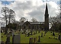
8
The Parish Church of St Saviour, Bamber Bridge
St Saviour's Church, on Church Road at the south end of the village, was built in 1836-37 to a Romanesque design by the Lancaster architect Edmund Sharpe. The church was considerably altered and enlarged in 1886 when the chancel and transepts were added in a similar style.
The church is a Grade II listed building (English Heritage Building ID: 358023 http://www.britishlistedbuildings.co.uk/en-358023-church-of-st-saviour-lancashire British Listed Buildings).
Image: © David Dixon
Taken: 11 Apr 2014
0.13 miles
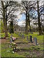
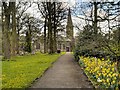
9
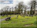
St Saviour's Churchyard, Bamber Bridge
Image: © David Dixon
Taken: 11 Apr 2014
0.13 miles
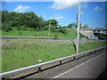
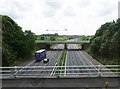
10
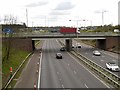
M6 Motorway at Cuerden Green
Looking southwards from A6 roundabout at junction 29 of the M6 motorway.
Image: © David Dixon
Taken: 11 Apr 2014
0.14 miles