IMAGES TAKEN NEAR TO
Wateringpool Lane, PRESTON, PR5 5UA
Introduction
This page details the photographs taken nearby to Wateringpool Lane, PR5 5UA by members of the Geograph project.
The Geograph project started in 2005 with the aim of publishing, organising and preserving representative images for every square kilometre of Great Britain, Ireland and the Isle of Man.

There are currently over 7.5m images from over14,400 individuals and you can help contribute to the project by visiting https://www.geograph.org.uk
Image Map (Loading...)


Getting Data...Please wait
Leaflet Map data © OpenStreetMap
Images are licensed for reuse under creativecommons.org/licenses/by-sa/2.0
Notes
- Clicking on the map will re-center to the selected point.
- The higher the marker number, the further away the image location is from the centre of the postcode.
Image Listing (11 Images Found)
Images are licensed for reuse under creativecommons.org/licenses/by-sa/2.0
Image
Details
Distance
1
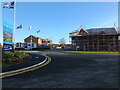
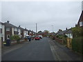
St. James' Fields housing under construction
Construction of housing has started on the fields to the east of Wateringpool Lane.
Image: © Adam C Snape
Taken: 27 Dec 2015
0.08 miles
2
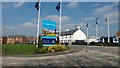
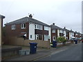
New Housing off Wateringpool Lane
St James' Fields is a new development on a field sandwiched between the disused railway, Wateringpool Lane and older housing at Doodstone's Nook. The new road in the view is officially named Central Park Avenue.
Image: © Paul Collins
Taken: 14 Apr 2018
0.10 miles
3
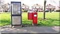
Kiosk and Postbox at Doodstone's Nook
These facilities are situated on a small green in Wateringspool Lane at the junction with Doodstone's Nook.
Image: © Paul Collins
Taken: 14 Apr 2018
0.12 miles
4
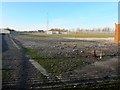
The gasometers have been dismantled
The last significant parts of the gasworks off Wateringpool Lane have been removed. Two large gas holding tanks stood in this location for many years. In August 2015 planning permission was given for the building of 280 homes on the former gasworks site: https://web.archive.org/web/20151229180207/http://www.leylandguardian.co.uk/news/local/former-gasworks-site-gets-the-go-ahead-for-280-new-homes-1-7411180
Image: © Adam C Snape
Taken: 27 Dec 2015
0.13 miles
5
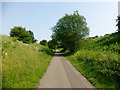
National Cycle Route 55.
Cycled from Grimsargh down the Guild Wheel then crossed the River Ribble on the Old Tram Road to head towards Lostock Hall and Bamber Bridge.
Image: © Rude Health
Taken: 5 Jul 2013
0.18 miles
8
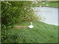
Swans nest
At the edge of a small lake. There were three eggs in the nest that I could see, as one of the pair had gone for a swim, but the other may have been sitting on some more eggs.
Image: © Margaret Clough
Taken: 8 May 2006
0.22 miles
9
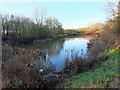
A pond near Walton Park
This pond is located in a bit of green space sandwiched between the Preston Junction Nature Reserve and the Walton Park housing estate. It was constructed as part of the development of the housing estate. The pond can also be accessed from Leigh Brow or via a woodland path from Old Tram Road. It falls within the area of the proposed South Ribble Central Park https://web.archive.org/web/20151005072030/http://www.southribble.gov.uk/sites/default/files/CentralparkMasterplan.pdf .
A photo taken from another angle: Image
Image: © Adam C Snape
Taken: 27 Dec 2015
0.24 miles
10
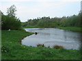
Small lake with swans nesting on the edge
There is a woodland walk alongside the lake and picnic tables.
Image: © Margaret Clough
Taken: 8 May 2006
0.24 miles