IMAGES TAKEN NEAR TO
Avondale Drive, PRESTON, PR5 5BQ
Introduction
This page details the photographs taken nearby to Avondale Drive, PR5 5BQ by members of the Geograph project.
The Geograph project started in 2005 with the aim of publishing, organising and preserving representative images for every square kilometre of Great Britain, Ireland and the Isle of Man.

There are currently over 7.5m images from over14,400 individuals and you can help contribute to the project by visiting https://www.geograph.org.uk
Image Map
Images are licensed for reuse under creativecommons.org/licenses/by-sa/2.0
Notes
- Clicking on the map will re-center to the selected point.
- The higher the marker number, the further away the image location is from the centre of the postcode.
Image Listing (15 Images Found)
Images are licensed for reuse under creativecommons.org/licenses/by-sa/2.0
Image
Details
Distance
1

The Sunflower Chinese Takeaway, Lostock Hall
There are NUMEROUS eating outlets and takeaways in Lostock Hall .... this is just one of them - the Sunflower Chinese Takeaway, right in the centre. This was taken on my way home tonight - I just managed to get home before the heavens opened (note the very dark clouds .....)
Image: © Mari Buckley
Taken: 18 Jun 2009
0.11 miles
2
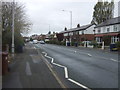
Brownedge Road, Lostock Hall
Looking west on the B5257.
Image: © JThomas
Taken: 25 Oct 2018
0.12 miles
3
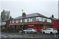
Off licence on Brownedge Road, Lostock Hall
Image: © JThomas
Taken: 25 Oct 2018
0.16 miles
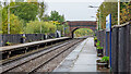
5
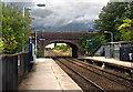
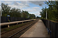
Lostock Hall railway station, Lancashire
Opened in 1984 by British Rail on the Blackburn to Preston line. View east from Watkin Lane bridge, towards Blackburn and Burnley. The original Lostock Hall station was behind the photographer on the west side of Watkin Lane.
Image: © Nigel Thompson
Taken: 7 Oct 2012
0.16 miles
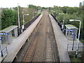
7
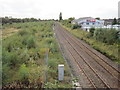
Lostock Hall railway station (site), Lancashire
Opened in 1849 by the East Lancashire Railway, later part of the Lancashire & Yorkshire Railway, on the line from Blackburn to Preston, this station closed in 1969 and was demolished.
View west from Watkin Lane bridge towards Preston, and previously towards Ormskirk and Liverpool. The Lostock Hall steam shed (closed 1968) occupied the derelict land to the left of the picture.
A new Lostock Hall station was opened in 1988 by British Rail, immediately behind the camera position. See Image
Image: © Nigel Thompson
Taken: 7 Oct 2012
0.18 miles
10
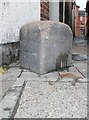
Old Boundary Marker by the B5254, Leyland Road, Tardy Gate
Parish Boundary Marker by the B5254, in parish of Penwortham (South Ribble District), Leyland Road, Tardy Gate, outside No.468, retail premises, opposite Tardy Gate PH.
Carved bench mark on Southeast face.
Surveyed
Milestone Society National ID: LA_PENFAR01pb
Image: © Milestone Society
Taken: Unknown
0.19 miles