IMAGES TAKEN NEAR TO
Linden Drive, PRESTON, PR5 5AT
Introduction
This page details the photographs taken nearby to Linden Drive, PR5 5AT by members of the Geograph project.
The Geograph project started in 2005 with the aim of publishing, organising and preserving representative images for every square kilometre of Great Britain, Ireland and the Isle of Man.

There are currently over 7.5m images from over14,400 individuals and you can help contribute to the project by visiting https://www.geograph.org.uk
Image Map
Images are licensed for reuse under creativecommons.org/licenses/by-sa/2.0
Notes
- Clicking on the map will re-center to the selected point.
- The higher the marker number, the further away the image location is from the centre of the postcode.
Image Listing (5 Images Found)
Images are licensed for reuse under creativecommons.org/licenses/by-sa/2.0
Image
Details
Distance
3
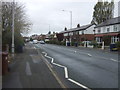
Brownedge Road, Lostock Hall
Looking west on the B5257.
Image: © JThomas
Taken: 25 Oct 2018
0.08 miles
4
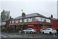
Off licence on Brownedge Road, Lostock Hall
Image: © JThomas
Taken: 25 Oct 2018
0.08 miles
5
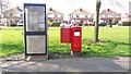
Kiosk and Postbox at Doodstone's Nook
These facilities are situated on a small green in Wateringspool Lane at the junction with Doodstone's Nook.
Image: © Paul Collins
Taken: 14 Apr 2018
0.13 miles