IMAGES TAKEN NEAR TO
Allerton Court, PRESTON, PR5 4QW
Introduction
This page details the photographs taken nearby to Allerton Court, PR5 4QW by members of the Geograph project.
The Geograph project started in 2005 with the aim of publishing, organising and preserving representative images for every square kilometre of Great Britain, Ireland and the Isle of Man.

There are currently over 7.5m images from over14,400 individuals and you can help contribute to the project by visiting https://www.geograph.org.uk
Image Map (Loading...)


Getting Data...Please wait
Leaflet Map data © OpenStreetMap
Images are licensed for reuse under creativecommons.org/licenses/by-sa/2.0
Notes
- Clicking on the map will re-center to the selected point.
- The higher the marker number, the further away the image location is from the centre of the postcode.
Image Listing (3 Images Found)
Images are licensed for reuse under creativecommons.org/licenses/by-sa/2.0
Image
Details
Distance
1
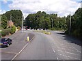
Roundabout on Chorley Road, Walton-le-Dale
North-facing view of the roundabout halfway down Cinnamon Hill on the B6258, Chorley Road. The roundabout was added to provide access to the recently-built Holland House housing estate to the right. To the left is the post-war Cinnamon Hill housing estate which was formerly accessed by a simple T-junction.
Image: © Raymond Knapman
Taken: 2 Aug 2012
0.10 miles
3
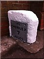
Old Milestone by the B5258, Chorley Road, Walton-le-Dale
Metal plate attached to stone post by the B5258, in parish of Bamber Bridge (South Ribble District), Walton le Dale, B6230 junction, against wall, on East side of road. Preston wedge, erected by the Wigan & Preston (north of Yarrow) turnpike trust in the 19th century.
Inscription reads:-
: TO / CHORLEY / 7 / MILES : : TO / PRESTON / 2 / MILES :
Pivot benchmark on top.
Milestone Society National ID: LA_CYPS07
Image: © J Higgins
Taken: 1 Apr 2009
0.19 miles