IMAGES TAKEN NEAR TO
Higher Walton Road, PRESTON, PR5 4HD
Introduction
This page details the photographs taken nearby to Higher Walton Road, PR5 4HD by members of the Geograph project.
The Geograph project started in 2005 with the aim of publishing, organising and preserving representative images for every square kilometre of Great Britain, Ireland and the Isle of Man.

There are currently over 7.5m images from over14,400 individuals and you can help contribute to the project by visiting https://www.geograph.org.uk
Image Map
Images are licensed for reuse under creativecommons.org/licenses/by-sa/2.0
Notes
- Clicking on the map will re-center to the selected point.
- The higher the marker number, the further away the image location is from the centre of the postcode.
Image Listing (46 Images Found)
Images are licensed for reuse under creativecommons.org/licenses/by-sa/2.0
Image
Details
Distance
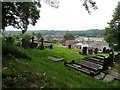
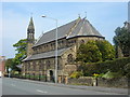
1
The Parish Church of St Leonard, Walton-le-Dale,Graveyard
Image: © Alexander P Kapp
Taken: 9 May 2008
0.06 miles
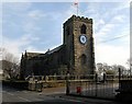
3
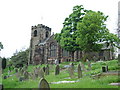
The Parish Church of St Leonard, Walton-le-Dale
Image: © Alexander P Kapp
Taken: 9 May 2008
0.06 miles
4
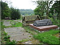
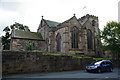
Churchyard in Walton - Le - Dale
The R.C. church of Our Lady and St. Patrick.
Image: © philandju
Taken: 19 Jun 2014
0.06 miles
5
Parish Church of St Leonard, Walton-le-Dale
Image: © Alexander P Kapp
Taken: 29 Sep 2005
0.06 miles
7
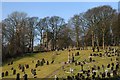
Cemetery of Our Lady and St. Patrick
Cemetery of Our Lady and St. Patrick with St. Leonard's church beyond the trees.
Image: © Galatas
Taken: 17 Feb 2010
0.06 miles
8
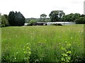
Wildflower meadow
By the A675 at Walton - Le - Dale.
Image: © philandju
Taken: 19 Jun 2014
0.06 miles
9
Our Lady & St. Patrick's RC church, Walton le Dale
Image: © Margaret Clough
Taken: 8 May 2006
0.06 miles