IMAGES TAKEN NEAR TO
Bridge Street, PRESTON, PR5 4DR
Introduction
This page details the photographs taken nearby to Bridge Street, PR5 4DR by members of the Geograph project.
The Geograph project started in 2005 with the aim of publishing, organising and preserving representative images for every square kilometre of Great Britain, Ireland and the Isle of Man.

There are currently over 7.5m images from over14,400 individuals and you can help contribute to the project by visiting https://www.geograph.org.uk
Image Map
Images are licensed for reuse under creativecommons.org/licenses/by-sa/2.0
Notes
- Clicking on the map will re-center to the selected point.
- The higher the marker number, the further away the image location is from the centre of the postcode.
Image Listing (31 Images Found)
Images are licensed for reuse under creativecommons.org/licenses/by-sa/2.0
Image
Details
Distance
2
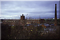
Higher Walton Mill
A wider view but somewhat spoilt by vegetation.
Image: © Chris Allen
Taken: 7 Nov 1986
0.04 miles
3

Higher Walton Mill, Walton-le-Dale
Originally owned by G & R Dewhurst and the older block has 1860 on the rainwater heads. A new engine house was built in 1901 to replace the original double beam engine. The mill was later owned by the Preston Tyre Fabric Manufacturing Co and is now in multiple occupancy.
Colin Bowden identified my image and pointed me to T C Dickinson (2002), Cotton Mills of Preston for more data.
Image: © Chris Allen
Taken: 7 Nov 1986
0.04 miles
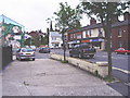
4
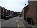
Brook Street, Higher Walton
A quick view along Brook Street.
Image: © Greum
Taken: 29 May 2023
0.04 miles
6
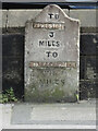
Old Milestone by the A675, Blackburn Road, Higher Walton
Carved stone post by the A675, in parish of BAMBER BRIDGE (SOUTH RIBBLE District), Albert Terrace, Blackburn Road, opposite Swan Inn, on Northeast side of road. Old Preston stone, erected by the Blackburn to Walton Cop turnpike trust in the 19th century.
Inscription reads:-
TO
PRESTON
3
MILES
TO
BLACKBURN
8
MILES
Milestone Society National ID: LA_PSBB03.
Image: © Ashley Preston
Taken: 23 Aug 2024
0.04 miles
7
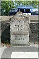
Old Milestone by the A675, Blackburn Road, Higher Walton
Carved stone post by the A675, in parish of BAMBER BRIDGE (SOUTH RIBBLE District), Albert Terrace, Blackburn Road, opposite Swan Inn, on Northeast side of road. Old Preston stone, erected by the Blackburn to Walton Cop turnpike trust in the 19th century.
Inscription reads:-
TO
PRESTON
3
MILES
TO
BLACKBURN
8
MILES
Milestone Society National ID: LA_PSBB03.
Image: © J Higgins
Taken: 1 Apr 2009
0.04 miles
9
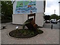
Mural and Ladle
On Cann Bridge Street, Higher Walter. http://www.geograph.org.uk/photo/4493967
Image: © Ian S
Taken: 24 May 2015
0.06 miles
10
Mural and Ladle
On Cann Bridge Street, Higher Walter. http://www.geograph.org.uk/photo/4493959
Image: © Ian S
Taken: 24 May 2015
0.06 miles