IMAGES TAKEN NEAR TO
Gib Lane, PRESTON, PR5 0RT
Introduction
This page details the photographs taken nearby to Gib Lane, PR5 0RT by members of the Geograph project.
The Geograph project started in 2005 with the aim of publishing, organising and preserving representative images for every square kilometre of Great Britain, Ireland and the Isle of Man.

There are currently over 7.5m images from over14,400 individuals and you can help contribute to the project by visiting https://www.geograph.org.uk
Image Map
Images are licensed for reuse under creativecommons.org/licenses/by-sa/2.0
Notes
- Clicking on the map will re-center to the selected point.
- The higher the marker number, the further away the image location is from the centre of the postcode.
Image Listing (23 Images Found)
Images are licensed for reuse under creativecommons.org/licenses/by-sa/2.0
Image
Details
Distance
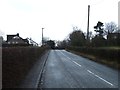
2
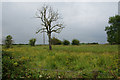
Fallow field by Gib Lane
The clouds were heavy and oppressive, adding to the starkness of the dead tree in the middle.
Image: © Bill Boaden
Taken: 14 Jun 2014
0.08 miles
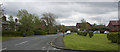
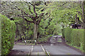
3
Cripple Gate Lane
A narrow cul-de-sac in Hoghton village.
Image: © philandju
Taken: 3 Aug 2022
0.08 miles
6
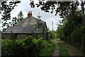
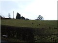
Blanket Hall
Inscription above the front door reads:- "1637 Blanket Hall 1952"
The building certainly looks to have been constructed well after the 17th Century.
Image: © Chris Heaton
Taken: 11 Sep 2021
0.10 miles
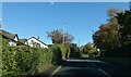
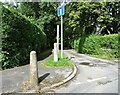
9
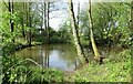
Duckpond in Hoghton
At the end of Cripple Gate Lane.
Image: © philandju
Taken: 3 May 2023
0.15 miles