IMAGES TAKEN NEAR TO
Shuttling Fields Lane, PRESTON, PR5 0LH
Introduction
This page details the photographs taken nearby to Shuttling Fields Lane, PR5 0LH by members of the Geograph project.
The Geograph project started in 2005 with the aim of publishing, organising and preserving representative images for every square kilometre of Great Britain, Ireland and the Isle of Man.

There are currently over 7.5m images from over14,400 individuals and you can help contribute to the project by visiting https://www.geograph.org.uk
Image Map
Images are licensed for reuse under creativecommons.org/licenses/by-sa/2.0
Notes
- Clicking on the map will re-center to the selected point.
- The higher the marker number, the further away the image location is from the centre of the postcode.
Image Listing (9 Images Found)
Images are licensed for reuse under creativecommons.org/licenses/by-sa/2.0
Image
Details
Distance
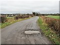
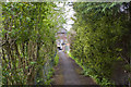
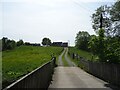
1
Shuttling Fields Lane
Shuttling Fields Lane provides access to a number of farms off Gregson Lane.
Image: © Greum
Taken: 29 May 2023
0.09 miles
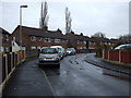
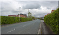
5
Gregson Lane, Higher Walton
Looking northwest along the road from the junction with Shuttling Fields Lane.
Image: © Greum
Taken: 29 May 2023
0.14 miles
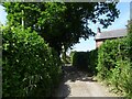
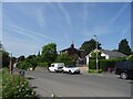
6
A junction of tracks
Shuttling Fields Lane forks right and winds downhill. The track ahead is a private access road to the farm.
Image: © Adam C Snape
Taken: 21 Feb 2016
0.15 miles
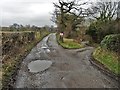
7
Track to Top o' th' Barn
This track crosses over Many Brooks Bridge and leads up to Top o' th' Barn.
Image: © Greum
Taken: 29 May 2023
0.20 miles