IMAGES TAKEN NEAR TO
Hoghton Lane, PRESTON, PR5 0JD
Introduction
This page details the photographs taken nearby to Hoghton Lane, PR5 0JD by members of the Geograph project.
The Geograph project started in 2005 with the aim of publishing, organising and preserving representative images for every square kilometre of Great Britain, Ireland and the Isle of Man.

There are currently over 7.5m images from over14,400 individuals and you can help contribute to the project by visiting https://www.geograph.org.uk
Image Map (Loading...)


Getting Data...Please wait
Leaflet Map data © OpenStreetMap
Images are licensed for reuse under creativecommons.org/licenses/by-sa/2.0
Notes
- Clicking on the map will re-center to the selected point.
- The higher the marker number, the further away the image location is from the centre of the postcode.
Image Listing (17 Images Found)
Images are licensed for reuse under creativecommons.org/licenses/by-sa/2.0
Image
Details
Distance
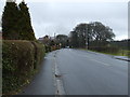
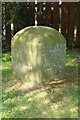
3
Old Boundary Marker by the A675, Hoghton Lane, Samlesbury Parish
Parish Boundary Marker by the A675, in parish of Samlesbury (South Ribble District), Hoghton Lane, opposite No. 299.
Surveyed
Milestone Society National ID: LA_PSBB04pb
Image: © Philip Platt
Taken: 15 Feb 2012
0.07 miles
5
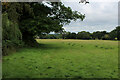
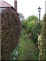
Footpath heading towards Coup Green
The footpath is invisible on the ground, although marked on the definitive map. It follows the hedgerow and trees along the southern perimeter of this pasture.
Image: © Chris Heaton
Taken: 11 Sep 2021
0.09 miles
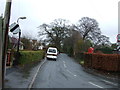
6
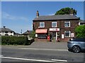
Hoghton Post Office
Hoghton Post Office lies between Straits Farm and the junction with Quaker Brook Lane.
Image: © Greum
Taken: 9 Jun 2023
0.11 miles
7
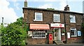
Hoghton Post Office
A good many villages have lost their post offices in recent years, but this one is still serving the public.
Image: © philandju
Taken: 22 May 2023
0.11 miles
8
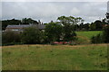
Heading towards Brook House Farm and Hoghton Lane
Crossing pasture towards the A675 in Hoghton
Image: © Chris Heaton
Taken: 11 Sep 2021
0.12 miles
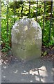
9
Old Boundary Marker by Quaker Brook Lane, Samlesbury Parish
Parish Boundary Marker by the UC road, in parish of Samlesbury (South Ribble District), Quaker Brook Lane, Outside gate of Cedar Court on verge, North side of lane.
Surveyed
Milestone Society National ID: LA_SAMHOG02pb
Image: © Philip Platt
Taken: 15 Feb 2012
0.18 miles
10
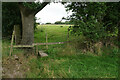
Path into the next field
The path crosses fields in the direction of Stanley Grange.
Image: © Bill Boaden
Taken: 30 Aug 2021
0.18 miles