IMAGES TAKEN NEAR TO
Bankhead Lane, PRESTON, PR5 0AA
Introduction
This page details the photographs taken nearby to Bankhead Lane, PR5 0AA by members of the Geograph project.
The Geograph project started in 2005 with the aim of publishing, organising and preserving representative images for every square kilometre of Great Britain, Ireland and the Isle of Man.

There are currently over 7.5m images from over14,400 individuals and you can help contribute to the project by visiting https://www.geograph.org.uk
Image Map
Images are licensed for reuse under creativecommons.org/licenses/by-sa/2.0
Notes
- Clicking on the map will re-center to the selected point.
- The higher the marker number, the further away the image location is from the centre of the postcode.
Image Listing (26 Images Found)
Images are licensed for reuse under creativecommons.org/licenses/by-sa/2.0
Image
Details
Distance
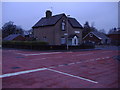
3
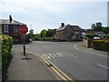
Four Lane Ends, Gregson Lane
The intersection of Gregson Lane, Bank Head Lane and Daub Hall Lane in the heart of the village taking its name from the former.
Image: © Greum
Taken: 29 May 2023
0.09 miles
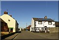
4
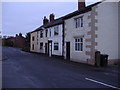
The Poplars, Four Lane Ends, Gregson Lane
House built 1874
Image: © Alan Sillitoe
Taken: 19 Jan 2008
0.09 miles
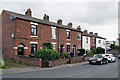
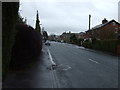
5
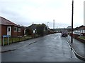
Gregson Lane
A small village near Preston.
Image: © philandju
Taken: 3 Apr 2023
0.12 miles
7
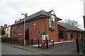
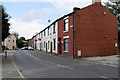
Trinity Methodist Church, Gregson Lane
Image: © Alexander P Kapp
Taken: 21 Mar 2006
0.12 miles
9
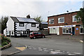
Mr Chips
A small group of shops set back from Gregson Lane near the centre of the village.
Image: © David Dixon
Taken: 9 Sep 2020
0.13 miles