IMAGES TAKEN NEAR TO
Shore Road, PRESTON, PR4 6XQ
Introduction
This page details the photographs taken nearby to Shore Road, PR4 6XQ by members of the Geograph project.
The Geograph project started in 2005 with the aim of publishing, organising and preserving representative images for every square kilometre of Great Britain, Ireland and the Isle of Man.

There are currently over 7.5m images from over14,400 individuals and you can help contribute to the project by visiting https://www.geograph.org.uk
Image Map
Images are licensed for reuse under creativecommons.org/licenses/by-sa/2.0
Notes
- Clicking on the map will re-center to the selected point.
- The higher the marker number, the further away the image location is from the centre of the postcode.
Image Listing (13 Images Found)
Images are licensed for reuse under creativecommons.org/licenses/by-sa/2.0
Image
Details
Distance
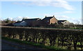
1
Farm buildings near Hesketh Bank, Lancashire
Image: © nick macneill
Taken: 1 Sep 2011
0.05 miles
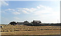
5
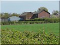
New Manor Farm
Off Shore Road, Hesketh.
Image: © Christine Johnstone
Taken: 17 Apr 2011
0.14 miles
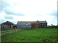
6
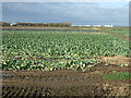
Fields north of Shore Road, Hesketh
Reclamation means that Shore Road is a long way from the shore these days.
Image: © Mike Pennington
Taken: 8 Aug 2016
0.14 miles
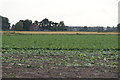
8
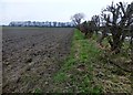
Ploughed Field
A ploughed flat field off Dib Road.
Image: © Rude Health
Taken: 16 Mar 2015
0.17 miles
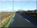
9
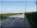
Shore Road, Hesketh
Presumably close to the original shoreline, before the marshes were reclaimed.
Image: © Christine Johnstone
Taken: 17 Apr 2011
0.19 miles