IMAGES TAKEN NEAR TO
Coe Lane, PRESTON, PR4 6HH
Introduction
This page details the photographs taken nearby to Coe Lane, PR4 6HH by members of the Geograph project.
The Geograph project started in 2005 with the aim of publishing, organising and preserving representative images for every square kilometre of Great Britain, Ireland and the Isle of Man.

There are currently over 7.5m images from over14,400 individuals and you can help contribute to the project by visiting https://www.geograph.org.uk
Image Map
Images are licensed for reuse under creativecommons.org/licenses/by-sa/2.0
Notes
- Clicking on the map will re-center to the selected point.
- The higher the marker number, the further away the image location is from the centre of the postcode.
Image Listing (42 Images Found)
Images are licensed for reuse under creativecommons.org/licenses/by-sa/2.0
Image
Details
Distance
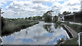
2
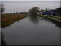
Rufford Branch off the Leeds Liverpool Canal
Image: © Robert Wade
Taken: 10 Jan 2009
0.16 miles
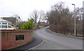
6
The Leeds and Liverpool Canal (Rufford Branch)
Seen from Town End Bridge
Image: © K A
Taken: 2 Jun 2013
0.17 miles
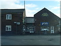
7
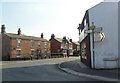
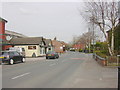
Junction of Hesketh Lane and Church Road, Tarleton
Image: © nick macneill
Taken: 1 Sep 2011
0.17 miles