IMAGES TAKEN NEAR TO
Walkdale, PRESTON, PR4 5SY
Introduction
This page details the photographs taken nearby to Walkdale, PR4 5SY by members of the Geograph project.
The Geograph project started in 2005 with the aim of publishing, organising and preserving representative images for every square kilometre of Great Britain, Ireland and the Isle of Man.

There are currently over 7.5m images from over14,400 individuals and you can help contribute to the project by visiting https://www.geograph.org.uk
Image Map
Images are licensed for reuse under creativecommons.org/licenses/by-sa/2.0
Notes
- Clicking on the map will re-center to the selected point.
- The higher the marker number, the further away the image location is from the centre of the postcode.
Image Listing (19 Images Found)
Images are licensed for reuse under creativecommons.org/licenses/by-sa/2.0
Image
Details
Distance
1
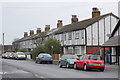
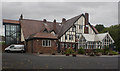
Anchor Drive, Hutton
The road shares its name with the pub at the road junction. The properties also share the half timbered effect design of the pub
Image: © K A
Taken: 26 Dec 2012
0.08 miles
3
The Anchor, 88 Liverpool Road, Hutton
Image: © Alexander P Kapp
Taken: 4 Jul 2008
0.09 miles
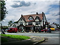
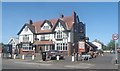
6

The Anchor Inn, Hutton
Large public house on Liverpool Road.
Image: © David Dixon
Taken: 12 May 2019
0.11 miles
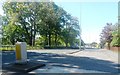
8
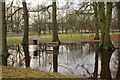
Bring your own wellingtons
A pair would definitely be needed to make use of this bench. Beyond the busy A59 trunk road is the headquartears of Lancashire Constabulary
Image: © K A
Taken: 26 Dec 2012
0.12 miles
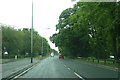
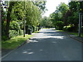
10
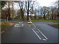
Approaching the A59
Ratten Lane meets Liverpool Road.
Image: © JThomas
Taken: 22 Nov 2014
0.13 miles