IMAGES TAKEN NEAR TO
Hall Carr Lane, PRESTON, PR4 5JL
Introduction
This page details the photographs taken nearby to Hall Carr Lane, PR4 5JL by members of the Geograph project.
The Geograph project started in 2005 with the aim of publishing, organising and preserving representative images for every square kilometre of Great Britain, Ireland and the Isle of Man.

There are currently over 7.5m images from over14,400 individuals and you can help contribute to the project by visiting https://www.geograph.org.uk
Image Map
Images are licensed for reuse under creativecommons.org/licenses/by-sa/2.0
Notes
- Clicking on the map will re-center to the selected point.
- The higher the marker number, the further away the image location is from the centre of the postcode.
Image Listing (9 Images Found)
Images are licensed for reuse under creativecommons.org/licenses/by-sa/2.0
Image
Details
Distance
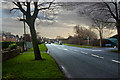
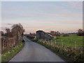
1
Hall Carr Lane, Walmer Bridge
Heading west.
Image: © JThomas
Taken: 22 Nov 2014
0.07 miles
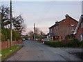
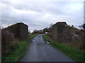
4
Hall Carr Lane, Longton
The stone walls on either side of the road are the remains of the railway bridge
Image: © Alexander P Kapp
Taken: 25 Nov 2010
0.21 miles
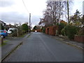
5
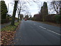
Liverpool New Road, Walmer Bridge
Heading north.
Image: © JThomas
Taken: 22 Nov 2014
0.21 miles
6
Remains of a disused railway bridge on Hall Carr Lane
Heading north west from Walmer Bridge.
Image: © JThomas
Taken: 22 Nov 2014
0.22 miles
7
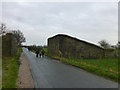
Bridge abutments on Hall Carr Lane
These are the remains of a railway bridge carrying the Preston to Southport line
Image: © Raymond Knapman
Taken: 9 Mar 2015
0.22 miles
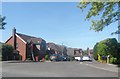
8
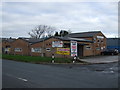
Factory units, Walmer Bridge
On Liverpool New Road.
Image: © JThomas
Taken: 22 Nov 2014
0.24 miles