IMAGES TAKEN NEAR TO
Dob Lane, PRESTON, PR4 4SU
Introduction
This page details the photographs taken nearby to Dob Lane, PR4 4SU by members of the Geograph project.
The Geograph project started in 2005 with the aim of publishing, organising and preserving representative images for every square kilometre of Great Britain, Ireland and the Isle of Man.

There are currently over 7.5m images from over14,400 individuals and you can help contribute to the project by visiting https://www.geograph.org.uk
Image Map
Images are licensed for reuse under creativecommons.org/licenses/by-sa/2.0
Notes
- Clicking on the map will re-center to the selected point.
- The higher the marker number, the further away the image location is from the centre of the postcode.
Image Listing (9 Images Found)
Images are licensed for reuse under creativecommons.org/licenses/by-sa/2.0
Image
Details
Distance
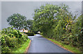
3
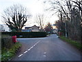
Junction of Moss Lane with Dob Lane
Image: © Alexander P Kapp
Taken: 26 Nov 2010
0.12 miles
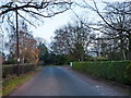
4
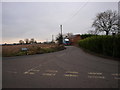
Moss Lane from Dob Lane
At the junction. The map didn't want to go far enough west
Image: © Maureen Taylor
Taken: 4 Jan 2009
0.13 miles
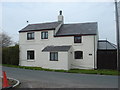
5
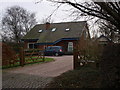
Lilac Cottage, Dob Lane, Little Hoole
Almost opposite the Moss Lane junction
Image: © Maureen Taylor
Taken: 4 Jan 2009
0.13 miles
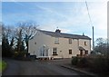
7
Hillock Farm
Knoll Lane, Little Hoole Moss Houses
Image: © Margaret Clough
Taken: 24 Apr 2006
0.19 miles