IMAGES TAKEN NEAR TO
Drumacre Lane West, PRESTON, PR4 4SB
Introduction
This page details the photographs taken nearby to Drumacre Lane West, PR4 4SB by members of the Geograph project.
The Geograph project started in 2005 with the aim of publishing, organising and preserving representative images for every square kilometre of Great Britain, Ireland and the Isle of Man.

There are currently over 7.5m images from over14,400 individuals and you can help contribute to the project by visiting https://www.geograph.org.uk
Image Map
Images are licensed for reuse under creativecommons.org/licenses/by-sa/2.0
Notes
- Clicking on the map will re-center to the selected point.
- The higher the marker number, the further away the image location is from the centre of the postcode.
Image Listing (6 Images Found)
Images are licensed for reuse under creativecommons.org/licenses/by-sa/2.0
Image
Details
Distance
1
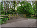
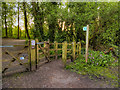
Entrance to Longton Brickroft (N)
The entrance to the northern part of the local nature reserve from Drumacre Lane West.
Image: © David Dixon
Taken: 12 May 2019
0.21 miles
2
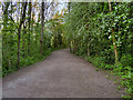
Longton Brickcroft, Path towards Middle Pond
Image: © David Dixon
Taken: 12 May 2019
0.22 miles
3
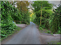
Drumacre Lane West
The western end of Drumacre Lane cuts through the Longton Brickcroft site.
Image: © David Dixon
Taken: 12 May 2019
0.22 miles
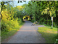
5
Entrance to Longton Brickroft (S)
The entrance to the southern part of the local nature reserve from Drumacre Lane West.
Image: © David Dixon
Taken: 12 May 2019
0.23 miles