IMAGES TAKEN NEAR TO
Copp Lane, PRESTON, PR4 3ZD
Introduction
This page details the photographs taken nearby to Copp Lane, PR4 3ZD by members of the Geograph project.
The Geograph project started in 2005 with the aim of publishing, organising and preserving representative images for every square kilometre of Great Britain, Ireland and the Isle of Man.

There are currently over 7.5m images from over14,400 individuals and you can help contribute to the project by visiting https://www.geograph.org.uk
Image Map
Images are licensed for reuse under creativecommons.org/licenses/by-sa/2.0
Notes
- Clicking on the map will re-center to the selected point.
- The higher the marker number, the further away the image location is from the centre of the postcode.
Image Listing (17 Images Found)
Images are licensed for reuse under creativecommons.org/licenses/by-sa/2.0
Image
Details
Distance
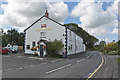
4
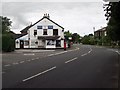
High Street, Elswick
Looking west along High Street towards Thistleton.
Image: © Roger May
Taken: 23 Aug 2005
0.17 miles
5
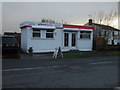
New homes information centre, Elswick
On High Street.
Image: © JThomas
Taken: 29 Nov 2014
0.18 miles
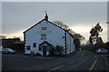
6
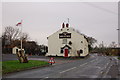
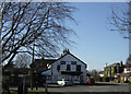
The Boot & Shoe Elswick
Very good Thwaites pub.
Image: © Keith Wright
Taken: 23 Dec 2005
0.18 miles
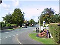
10
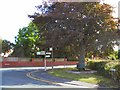
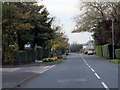
Country Seat
A shady spot to rest the feet, at the crossroads in Elswick.
Image: © Roger May
Taken: 23 Aug 2005
0.20 miles