IMAGES TAKEN NEAR TO
Heron Close, PRESTON, PR4 3FH
Introduction
This page details the photographs taken nearby to Heron Close, PR4 3FH by members of the Geograph project.
The Geograph project started in 2005 with the aim of publishing, organising and preserving representative images for every square kilometre of Great Britain, Ireland and the Isle of Man.

There are currently over 7.5m images from over14,400 individuals and you can help contribute to the project by visiting https://www.geograph.org.uk
Image Map
Images are licensed for reuse under creativecommons.org/licenses/by-sa/2.0
Notes
- Clicking on the map will re-center to the selected point.
- The higher the marker number, the further away the image location is from the centre of the postcode.
Image Listing (6 Images Found)
Images are licensed for reuse under creativecommons.org/licenses/by-sa/2.0
Image
Details
Distance
1
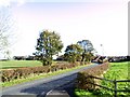
Medlar-with-Wesham
Looking east down Mowbreck Lane towards Mowbreck Hall, from the entrance to the Hospital Rehabilitation Centre.
The original Mowbreck Hall, owned by the Westby family for over 500 years, and a Catholic stronghold, although now lost and re-built, was reputed to be haunted and has links with Shakespeare. Mowbreck Hall Farm, nearby, remains. Mowbreck lane may be followed to Treales.
Image: © Roger May
Taken: 7 Nov 2005
0.08 miles
2
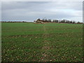
Footpath over field
Heading north from Mowbreck Lane.
Image: © JThomas
Taken: 1 Nov 2014
0.08 miles
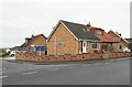
3
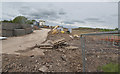
Building works off Mowbreck Lane
Probably housing
Image: © Ian Greig
Taken: 9 May 2018
0.09 miles
6
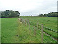
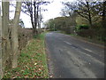
Stile at a footpath junction, near Wesham Hall
At the stile, the footpath running alongside the fence crosses to the other side of the fence, and another footpath heads off east [right].
Image: © Christine Johnstone
Taken: 5 Oct 2015
0.23 miles